1920s Maps of Union County, Illinois
Explore 7 historic maps of Union County from the 1920s. These maps offer a rare glimpse into what life looked like during the 1920s — showing old roads, neighborhoods, homes, and landmarks that have changed or disappeared over time.
Whether you're researching your family's past, planning a metal detecting trip, or studying how Union County's landscape evolved across the 1920s, these high-resolution maps are a powerful tool for exploring the history of this region.
- Focus on a specific era: All maps on this page are from the 1920s, giving you a focused view of this time period.
- See what’s changed: Compare century-old streets, trails, and buildings to today's modern landscape using overlays and satellite layers.
- Research with precision: Use these maps for genealogy, historical research, land use analysis, or educational projects.
- View, download, or print: Maps are fully viewable online in high resolution, and can be downloaded or printed for your own records.
Start exploring Union County's history through authentic maps from the 1920s. This is your window into the past.
Union County, IL maps
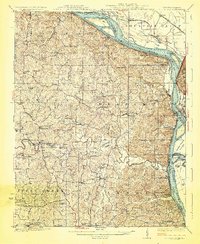
(7)- 1920 Map of Jonesboro
 1920 Jonesboro1920 Print · USGSSouthern Illinois during the late post-war era reveals a complex landscape of Mississippi riverfront bottoms and high ridges. Genealogists can trace family roots through numerous local landmarks, from the Casper Church to rural schools like Big Barn School and McClure School.
 - 1920 Map of Dongola, 1953 Print
 1920 Dongola1953 Print · USGSSouthern Illinois at the close of the 1910s reveals a landscape of river-bottom farms and busy rail junctions. Genealogists can trace family roots through dozens of local landmarks like Beech Grove School, Joppa Junction, and the State Hospital.3 unique versions available
 - 1922 Map of Carbondale
 1922 Carbondale1922 Print · USGSSouthern Illinois in the early 1920s is captured here at the height of its rail-driven rural development. Genealogists can trace family connections through dozens of named rural sites like Stone School, Cottage Home Church, and the Illinois Central corridor.3 unique versions available
 - 1923 Map of Dongola
 1923 Dongola1923 Print · USGSSouthern Illinois in the early twenties reveals a landscape of marshy river bottoms and upland family farms. Researchers can trace ancestral locations through dozens of named rural sites like St Johns Church, Egypt School, and Hoppa Junction.2 unique versions available
 - 1923 Map of Jonesboro
 1923 Jonesboro1923 Print · USGSThe Mississippi River bottoms and Shawnee hills meet in the early 1920s, showing a landscape of rail-dependent towns and rural schools. Trace family roots at Casper Church, follow the Mobile and Ohio Railroad, or locate Moccasin Springs.2 unique versions available
 - 1924 Map of Alto Pass
 1924 Alto Pass1924 Print · USGSSouthern Illinois at the peak of the rail era shows a landscape of river ferries and ridge-top settlements. Genealogists can trace family footprints across dozens of local landmarks like Rattlesnake Ferry, Goodbread Church, and Worthen School.2 unique versions available
 - 1925 Map of Altenburg
 1925 Altenburg1925 Print · USGSEastern Perry County and the Mississippi riverfront are documented here during the mid-twenties, showcasing a landscape of Saxon Lutheran heritage and river commerce. Genealogists can locate family landmarks like New Bethel Church, Hager School, and the vanished river site of Wittenberg.3 unique versions available
End of results
Showing maps 1-7 of 7
Top cities of Union County
- Anna historical maps
- Jonesboro historical maps
- Cobden historical maps
- Dongola historical maps
- Alto Pass historical maps
- Mill Creek historical maps
Frequently asked questions
- What are the different types of historical maps available for Union County?
- What is the oldest map of Union County?
- Where can I purchase historical maps of Union County for my home or office?
- Where can I download high-res historical maps of Union County?
- Are there historical topographic maps available for Union County?
- Is there historical aerial imagery available for Union County?
- Where are historical maps of Union County sourced from?