1940s Maps of Union County, Illinois
Explore 20 historic maps of Union County from the 1940s. These maps offer a rare glimpse into what life looked like during the 1940s — showing old roads, neighborhoods, homes, and landmarks that have changed or disappeared over time.
Whether you're researching your family's past, planning a metal detecting trip, or studying how Union County's landscape evolved across the 1940s, these high-resolution maps are a powerful tool for exploring the history of this region.
- Focus on a specific era: All maps on this page are from the 1940s, giving you a focused view of this time period.
- See what’s changed: Compare century-old streets, trails, and buildings to today's modern landscape using overlays and satellite layers.
- Research with precision: Use these maps for genealogy, historical research, land use analysis, or educational projects.
- View, download, or print: Maps are fully viewable online in high resolution, and can be downloaded or printed for your own records.
Start exploring Union County's history through authentic maps from the 1940s. This is your window into the past.
Union County, IL maps
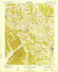
(20)- 1941 Map of Carbondale, 1955 Print
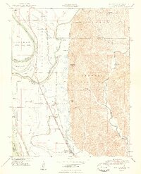
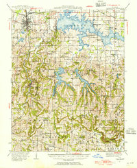 1941 Carbondale1955 Print · USGSSouthern Illinois was undergoing a transformation in the early 1940s as new reservoirs reshaped the topography near Carbondale. Researchers can trace rural life through dozens of named sites like Clemmenstown School and South County Line Church.2 unique versions available
 - 1947 Map of Jonesboro, 1954 Print
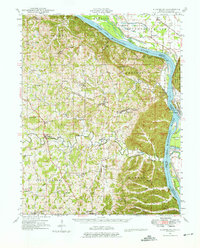
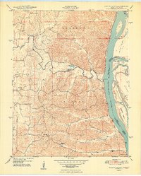
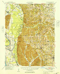
 1947 Jonesboro1954 Print · USGSSouthern Illinois in the late 1940s reveals a landscape defined by the Mississippi riverfront and the deep woods of the Shawnee National Forest. Researchers can trace early rural infrastructure through numerous sites like Egypt Mills, Dutch Mills, and the historic Kornthal Church.3 unique versions available
 - 1947 Map of Alto Pass, 1954 Print
 1947 Alto Pass1954 Print · USGSSouthern Illinois in the late 1940s is defined by the high ridges of the Shawnee Hills and the sweeping Mississippi floodplains. Researchers can trace rural life through sites like Dutch Ridge Church, the Macedonia School, and the river crossing at Rattlesnake Ferry.2 unique versions available
 - 1947 Map of Mc Clure, 1954 Print
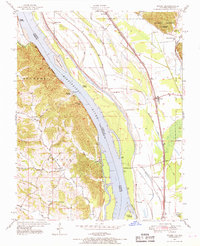
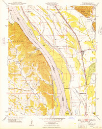
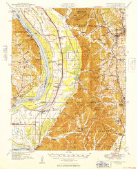
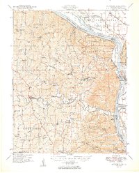
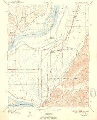 1947 Mc Clure1954 Print · USGSThe Illinois-Missouri borderlands along the Mississippi River come to life in the late 1940s, showing a landscape defined by flood control and rail transport. Trace local history through the Illinois Central Railroad and landmarks like McClure or Hobbs Chapel.3 unique versions available
 - 1947 Map of Wolf Lake, 1966 Print
 1947 Wolf Lake1966 Print · USGSThe Mississippi River bottoms and Shawnee National Forest hills meet in the late 1940s, showing a landscape shaped by rail and river. Genealogists can trace local landmarks like Galilee Ch and rural schoolhouses such as Cauble Sch and McCann Sch.3 unique versions available
 - 1947 Map of Ware, 1969 Print
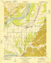
 1947 Ware1969 Print · USGSThe Mississippi River border near Ware and Egypt Mills is captured here in the late 1940s, showing a landscape of fertile floodplains and wooded bluffs. Researchers can trace historic river access points like Neelys Landing and several rural schoolhouses, including Big Barn Sch and Iona Sch.3 unique versions available
 - 1947 Map of Cobden, 1970 Print
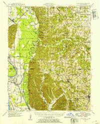
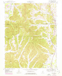
 1947 Cobden1970 Print · USGSSouthern Illinois fruit and timber country is well-documented in the late 1940s, showing the ridge-top settlements of the Shawnee National Forest. Trace the old rail lines through Alto Pass and Mountain Glen or locate family sites like Lyerle Chapel and Rendleman School.3 unique versions available
 - 1947 Map of Altenburg, 1976 Print
 1947 Altenburg1976 Print · USGSSoutheastern Missouri's river bluffs and Lutheran heritage are documented here in the mid-forties, showing the close-knit network of river landings and small-town commerce. Genealogists can trace family footprints across Altenburg, Frohna, and dozens of rural schools like Fiehler Sch or Buckeye Sch.
 - 1947 Map of Mill Creek, 1978 Print
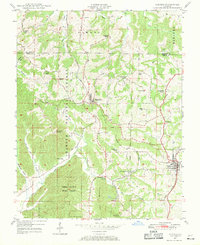
 1947 Mill Creek1978 Print · USGSSouthern Illinois at the edge of the Shawnee Hills comes alive in this mid-century survey of the Union and Alexander County line. Genealogists can locate family burial sites like McClure Cem and Sims Cem or trace the old rail lines serving Mill Creek and Tamms.2 unique versions available
 - 1948 Map of Cobden
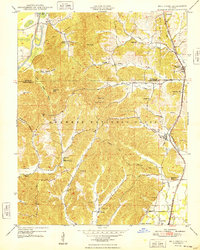
 1948 Cobden1948 Print · USGSSouthern Illinois hill country appears in the late 1940s as a region of dense forests and vital rail corridors. Genealogists can locate family names and rural landmarks like Jerusalem Church, Rendleman School, and the Bald Knob Lookout Tower.2 unique versions available
 - 1948 Map of Ware
 1948 Ware1948 Print · USGSThe Mississippi River corridor bustles with river and rail activity just after the war, connecting small Illinois landings with the Missouri hills. Genealogists can trace family roots through several rural schoolhouses like Miller Pond Sch and Iona Sch, or locate the Rallp Cem near the Shawnee National Forest.2 unique versions available
 - 1948 Map of McClure
 1948 McClure1948 Print · USGSThe Mississippi River bottomlands at the Illinois-Missouri border are captured here just after the war. Local researchers can trace family landmarks like Lindsey Cem or old schoolhouses such as Reynoldsville Sch and East Cape Girardeau School.
 - 1948 Map of Jonesboro
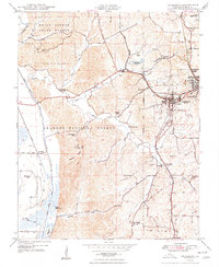 1948 Jonesboro1948 Print · USGSSouthern Illinois in the late 1940s centers on the rail junction at Jonesboro and Anna amidst the national forest. Researchers can trace numerous country schools and churches, such as Misenheimer Sch and Kornthal Ch.4 unique versions available
 - 1948 Map of Wolf Lake
 1948 Wolf Lake1948 Print · USGSThe Illinois-Missouri borderlands at the end of the 1940s reveal a landscape of river-driven commerce and scattered rural schoolhouses. Genealogists can trace family footprints at Galilee Ch, Bennett Landing, and the many namesake schools like McCann Sch and McGuire Sch.2 unique versions available
 - 1948 Map of Mill Creek
 1948 Mill Creek1948 Print · USGSSouthern Illinois hill country comes alive in the late 1940s as the railroad connects the timber and creek valleys of the Shawnee National Forest. Genealogists and historians can trace family locations through McClure Cem, Hazelwood School, and the village of Elco.2 unique versions available
 - 1948 Map of Neelys Landing
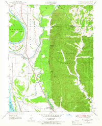
 1948 Neelys Landing1948 Print · USGSThe Missouri-Illinois river border is captured here in the late 1940s, showing a landscape of small river landings and ridge-top farms. Genealogists can trace family footprints at New Wells, the New Bethel Ch, and several rural schoolhouses like Oak Hill Sch.5 unique versions available
 - 1949 Map of Jonesboro
 1949 Jonesboro1949 Print · USGSSouthern Illinois and eastern Missouri meet along the river in the late 1940s, showing a landscape of fertile bottomlands and timbered ridges. Genealogists can locate family landmarks like Kornthal Church, Tripp Cem, and the Misenheimer School.
 - 1949 Map of Alto Pass
 1949 Alto Pass1949 Print · USGSSouthern Illinois river life and hill country are captured here shortly after the war, showing the Mississippi corridor in detail. You can trace old river crossings like Rattlesnake Ferry and locate rural landmarks such as Bald Knob, Lyerle Chapel, and the Hickory Ridge School.
 - 1949 Map of Paducah
 1949 Paducah1949 Print · USGSThe confluence of the Ohio, Mississippi, Tennessee, and Cumberland rivers at the close of the 1940s reveals a region bound by water and rail. Researchers can trace historic river landings, timberlands in the Shawnee National Forest, and the coal-mining infrastructure around West Frankfort and Herrin.2 unique versions available
 - 1949 Map of Altenburg
 1949 Altenburg1949 Print · USGSMid-century Perry and Cape Girardeau counties show a landscape of tight-knit rural communities along the Mississippi River just after the war. Family historians can trace ancestral roots through numerous local landmarks like Uniontown Sch, New Wells School, and the river landings at Wittenberg and Hines Landing.3 unique versions available
End of results
Showing maps 1-20 of 20
Top cities of Union County
- Anna historical maps
- Jonesboro historical maps
- Cobden historical maps
- Dongola historical maps
- Alto Pass historical maps
- Mill Creek historical maps
Frequently asked questions
- What are the different types of historical maps available for Union County?
- What is the oldest map of Union County?
- Where can I purchase historical maps of Union County for my home or office?
- Where can I download high-res historical maps of Union County?
- Are there historical topographic maps available for Union County?
- Is there historical aerial imagery available for Union County?
- Where are historical maps of Union County sourced from?