1970s Maps of Warren County, Illinois
Explore 4 historic maps of Warren County from the 1970s. These maps offer a rare glimpse into what life looked like during the 1970s — showing old roads, neighborhoods, homes, and landmarks that have changed or disappeared over time.
Whether you're researching your family's past, planning a metal detecting trip, or studying how Warren County's landscape evolved across the 1970s, these high-resolution maps are a powerful tool for exploring the history of this region.
- Focus on a specific era: All maps on this page are from the 1970s, giving you a focused view of this time period.
- See what’s changed: Compare century-old streets, trails, and buildings to today's modern landscape using overlays and satellite layers.
- Research with precision: Use these maps for genealogy, historical research, land use analysis, or educational projects.
- View, download, or print: Maps are fully viewable online in high resolution, and can be downloaded or printed for your own records.
Start exploring Warren County's history through authentic maps from the 1970s. This is your window into the past.
Warren County, IL maps
(4)- 1974 Map of Roseville, 1978 Print
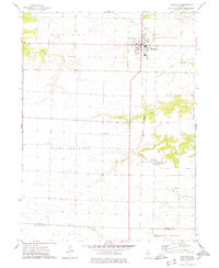 1974 Roseville1978 Print · USGSThe agricultural plains of Warren County are shown in detail during the mid-seventies, centered on the village of Roseville. Genealogists and local historians can locate several rural burial grounds such as Memorial Park Cem and Point Pleasant Cem, alongside the Burlington Northern rail line.
 - 1974 Map of Avon, 1978 Print
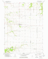
 1974 Avon1978 Print · USGSThe rail-corridor communities of west-central Illinois are documented here in the mid-1970s as they transition into the late twentieth century. Researchers can locate numerous family-named burial grounds like Babbitt Cem or trace the rural footprint of Saunders Hospital and the Long Landing Strip.
 - 1974 Map of Raritan, 1978 Print
 1974 Raritan1978 Print · USGSRaritan and the surrounding prairie townships are captured here in the mid-1970s, showcasing the intersection of three Illinois counties. Researchers can trace land divisions and local landmarks like St Patricks Ch and the headwaters of the La Moine River.
 - 1974 Map of Greenbush, 1978 Print
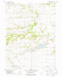 1974 Greenbush1978 Print · USGSThe rural borderlands of Warren and McDonough counties are captured here in the mid-1970s, showing a landscape of small townships and prairie creeks. Genealogists can locate family-named sites like McMahill Cem and Bond Cem or trace the Burlington Northern line near Youngstown.
End of results
Showing maps 1-4 of 4
Top cities of Warren County
- Monmouth historical maps
- Roseville historical maps
- Kirkwood historical maps
- Greenbush historical maps
- Coldbrook historical maps
- Berwick historical maps
See more
Frequently asked questions
- What are the different types of historical maps available for Warren County?
- What is the oldest map of Warren County?
- Where can I purchase historical maps of Warren County for my home or office?
- Where can I download high-res historical maps of Warren County?
- Are there historical topographic maps available for Warren County?
- Is there historical aerial imagery available for Warren County?
- Where are historical maps of Warren County sourced from?