1900s (20th Century) Maps of Warren County, Illinois
Explore 52 historic maps of Warren County from the 1900s (20th Century). These maps offer a rare glimpse into what life looked like during the 1900s — showing old roads, neighborhoods, homes, and landmarks that have changed or disappeared over time.
Whether you're researching your family's past, planning a metal detecting trip, or studying how Warren County's landscape evolved across the 1900s, these high-resolution maps are a powerful tool for exploring the history of this region.
- Focus on a specific era: All maps on this page are from the 1900s, giving you a focused view of this time period.
- See what’s changed: Compare century-old streets, trails, and buildings to today's modern landscape using overlays and satellite layers.
- Research with precision: Use these maps for genealogy, historical research, land use analysis, or educational projects.
- View, download, or print: Maps are fully viewable online in high resolution, and can be downloaded or printed for your own records.
Start exploring Warren County's history through authentic maps from the 1900s. This is your window into the past.
Warren County, IL maps
(52)- 1915 Map of Avon
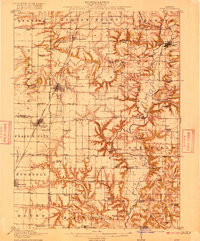 1915 Avon1915 Print · USGSWestern Illinois farm country and the Spoon River valley are shown here in the early twentieth century. Family history researchers can trace the locations of dozens of vanished rural schoolhouses like Oldtown School and Gross School, along with the small settlement of Check Row.3 unique versions available
 - 1916 Map of Good Hope, 1965 Print
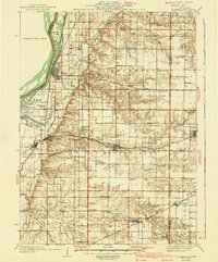
 1916 Good Hope1965 Print · USGSWestern Illinois prairie life is frozen in time during the First World War era as small farming communities began to peak. Genealogists can locate family-named landmarks like Stem School or Mud College and trace the original Chicago Burlington and Quincy rail line.2 unique versions available
 - 1918 Map of La Harpe
 1918 La Harpe1918 Print · USGSWestern Illinois farm life in the late teens is captured here through a remarkably dense grid of rural schools and rail-fed townships. Genealogists can trace family footprints across dozens of local districts like Sunny Ridge School and Waggy School or along the Santa Fe line.4 unique versions available
 - 1918 Map of Good Hope
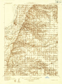
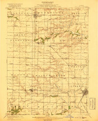 1918 Good Hope1918 Print · USGSCentral Illinois prairie and growing rail towns are captured here at the end of the Great War. Genealogists can locate family homesteads near dozens of country schools like Mud College and rural hubs such as Good Hope and Sciota.2 unique versions available
 - 1921 Map of Monmouth, 1961 Print
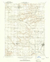
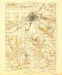
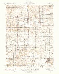
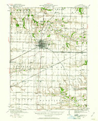 1921 Monmouth1961 Print · USGSWarren County at the opening of the 1920s reveals a bustling agricultural landscape centered on the rail hub of Monmouth. Genealogists and historians can trace dozens of country schools and vanished locales like Coonville, Farmers Academy, and the County Farm.3 unique versions available
 - 1923 Map of Monmouth
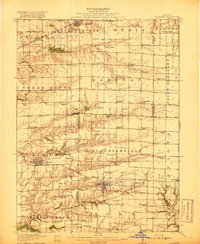
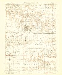 1923 Monmouth1923 Print · USGSWarren County in the early twenties was a thriving prairie landscape defined by its dense network of rural schools and rail junctions. Researchers can trace dozens of early educational sites like Hickory College and Scotchtown School or locate the historic COUNTY FARM near the hub of Monmouth.2 unique versions available
 - 1923 Map of Alexis
 1923 Alexis1923 Print · USGSNorthwestern Illinois at the height of the steam-rail era shows a countryside dotted with local schools and coal-hauling branch lines. Genealogists and historians can trace family ties to Ohio Grove Church, Mann Cemetery, or vanished stops like Shale City.2 unique versions available
 - 1925 Map of Alexis
 1925 Alexis1925 Print · USGSThe Illinois prairie of the 1920s is preserved here through a remarkably detailed network of rural schoolhouses and railroad stops. Trace the paths of the Rock Island Southern through Shale City or locate family roots at Ohio Grove Church and Mann Cemetery.
 - 1925 Map of Galesburg, 1968 Print
 1925 Galesburg1968 Print · USGSGalesburg and the surrounding Knox County townships appear here as a thriving rail and agricultural center between the world wars. Researchers can trace dozens of rural school sites and early landmarks like Lake Bracken, Orange Chapel, and the East Galesburg Randall PO.2 unique versions available
 - 1927 Map of Galesburg
 1927 Galesburg1927 Print · USGSKnox County is captured in the mid-twenties at its peak as a Midwestern rail hub centered on Galesburg. Local historians can trace dozens of rural school sites like Log City School or explore the early footprints of Knoxville and Abingdon.3 unique versions available
 - 1934 Map of Oquawka
 1934 Oquawka1934 Print · USGSHenderson County river life and prairie farming are captured here in the mid-thirties, from the Mississippi sloughs to the railroad towns. Genealogists can locate family landmarks including the County Farm, Coghill Cem, and the Little Brick Sch.3 unique versions available
 - 1935 Map of Keithsburg
 1935 Keithsburg1935 Print · USGSMercer County during the mid-thirties reveals a landscape of river towns and railroad junctions along the Mississippi. Genealogists and local historians can trace rural roots at Peniel Ch, Brick Cem, and numerous schoolhouses like Hazel Dell Sch.4 unique versions available
 - 1940 Map of Oquawka
 1940 Oquawka1940 Print · USGSHenderson County's river-and-rail economy is captured here during the 1930s as the Mississippi River environment meets an expanding network of rural towns. Genealogists and historians can trace dozens of country schoolhouses and cemeteries, from the Little Brick Sch to South Henderson Cem.2 unique versions available
 - 1941 Map of Keithsburg
 1941 Keithsburg1941 Print · USGSThe Mississippi River front in Mercer County thrived during the early 1940s as a hub of rail and river commerce. Genealogists can trace family footprints through dozens of rural landmarks, from Peniel Ch to schoolhouses like Prouty Sch and Lee Sch.2 unique versions available
 - 1944 Map of Avon, 1962 Print
 1944 Avon1962 Print · USGSThe Illinois prairie landscape between Bushnell and London Mills is shown here as it appeared in the mid-forties. Genealogists can trace family footprints across dozens of country school sites like Oldtown School and small junctions including Blyton and Babylon.
 - 1947 Map of Woodhull
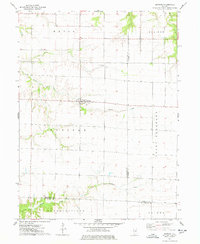
 1947 Woodhull1947 Print · USGSThe Illinois prairie at mid-century reveals a dense network of family farms and rural institutions near the Henry and Knox county lines. Genealogists can trace ancestral sites through dozens of named schools and cemeteries like Prairie Flower Sch and Oxford Cem.2 unique versions available
 - 1958 Map of Burlington, 1968 Print
 1958 Burlington1968 Print · USGSThe tri-state river country of Iowa, Illinois, and Missouri is captured here in the mid-fifties, dominated by the Mississippi River and major rail lines. Genealogists and historians can trace the development of river towns like Keokuk or locate the sprawling Iowa Army Ammunition Plant.4 unique versions available
 - 1958 Map of Davenport, 1968 Print
 1958 Davenport1968 Print · USGSEastern Iowa and western Illinois thrive along the river during the late fifties, defined by the industrial Quad Cities and a robust rail network. Genealogists can trace family roots through settlements like Oasis and Stanwood or along the Cedar River.2 unique versions available
 - 1961 Map of Burlington
 1961 Burlington1961 Print · USGSThe tri-state borderlands along the Mississippi River are captured here during the late fifties and early sixties, showing the vital river-and-rail economy of Iowa, Illinois, and Missouri. Genealogists and historians can trace the development of major hubs like Galesburg and Macomb alongside landmark sites such as the Iowa Ordnance Plant and the historic river town of Nauvoo.
 - 1961 Map of Davenport
 1961 Davenport1961 Print · USGSThe Quad Cities and the eastern Iowa riverlands are captured here in the early sixties, showing the region's transition into a modern industrial and transit hub. Genealogists and historians can trace the paths of major railroads and find river landmarks like Rock Island Arsenal, Huron Island, and the Coralville Reservoir.
 - 1962 Map of Davenport
 1962 Davenport1962 Print · USGSThe Quad Cities and the Mississippi River corridor are shown at their industrial peak just before the interstate era fully transformed the region. Researchers can trace the sprawling rail networks of the Chicago Rock Island and Pacific and find landmarks like the Rock Island Arsenal and Wild Cat Den State Park.
 - 1963 Map of Burlington
 1963 Burlington1963 Print · USGSThe tri-state river country of the Mississippi and Illinois valleys comes alive in this mid-century survey. Genealogists and historians can trace the industrial and academic growth of the region, from the Iowa Ordnance Plant to campuses like Knox College and Western Illinois University.
 - 1974 Map of Roseville, 1978 Print
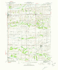
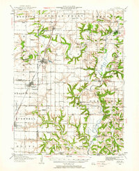
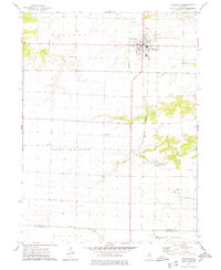 1974 Roseville1978 Print · USGSThe agricultural plains of Warren County are shown in detail during the mid-seventies, centered on the village of Roseville. Genealogists and local historians can locate several rural burial grounds such as Memorial Park Cem and Point Pleasant Cem, alongside the Burlington Northern rail line.
 - 1974 Map of Avon, 1978 Print
 1974 Avon1978 Print · USGSThe rail-corridor communities of west-central Illinois are documented here in the mid-1970s as they transition into the late twentieth century. Researchers can locate numerous family-named burial grounds like Babbitt Cem or trace the rural footprint of Saunders Hospital and the Long Landing Strip.
 - 1974 Map of Raritan, 1978 Print
 1974 Raritan1978 Print · USGSRaritan and the surrounding prairie townships are captured here in the mid-1970s, showcasing the intersection of three Illinois counties. Researchers can trace land divisions and local landmarks like St Patricks Ch and the headwaters of the La Moine River.
Showing maps 1-25 of 52
Top cities of Warren County
- Monmouth historical maps
- Roseville historical maps
- Kirkwood historical maps
- Greenbush historical maps
- Coldbrook historical maps
- Berwick historical maps
See more
Frequently asked questions
- What are the different types of historical maps available for Warren County?
- What is the oldest map of Warren County?
- Where can I purchase historical maps of Warren County for my home or office?
- Where can I download high-res historical maps of Warren County?
- Are there historical topographic maps available for Warren County?
- Is there historical aerial imagery available for Warren County?
- Where are historical maps of Warren County sourced from?