1920s Maps of Warren County, Illinois
Explore 6 historic maps of Warren County from the 1920s. These maps offer a rare glimpse into what life looked like during the 1920s — showing old roads, neighborhoods, homes, and landmarks that have changed or disappeared over time.
Whether you're researching your family's past, planning a metal detecting trip, or studying how Warren County's landscape evolved across the 1920s, these high-resolution maps are a powerful tool for exploring the history of this region.
- Focus on a specific era: All maps on this page are from the 1920s, giving you a focused view of this time period.
- See what’s changed: Compare century-old streets, trails, and buildings to today's modern landscape using overlays and satellite layers.
- Research with precision: Use these maps for genealogy, historical research, land use analysis, or educational projects.
- View, download, or print: Maps are fully viewable online in high resolution, and can be downloaded or printed for your own records.
Start exploring Warren County's history through authentic maps from the 1920s. This is your window into the past.
Warren County, IL maps
(6)- 1921 Map of Monmouth, 1961 Print
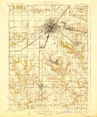
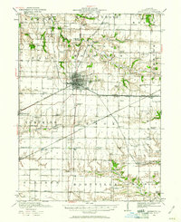 1921 Monmouth1961 Print · USGSWarren County at the opening of the 1920s reveals a bustling agricultural landscape centered on the rail hub of Monmouth. Genealogists and historians can trace dozens of country schools and vanished locales like Coonville, Farmers Academy, and the County Farm.3 unique versions available
 - 1923 Map of Monmouth
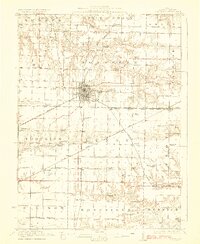 1923 Monmouth1923 Print · USGSWarren County in the early twenties was a thriving prairie landscape defined by its dense network of rural schools and rail junctions. Researchers can trace dozens of early educational sites like Hickory College and Scotchtown School or locate the historic COUNTY FARM near the hub of Monmouth.2 unique versions available
 - 1923 Map of Alexis
 1923 Alexis1923 Print · USGSNorthwestern Illinois at the height of the steam-rail era shows a countryside dotted with local schools and coal-hauling branch lines. Genealogists and historians can trace family ties to Ohio Grove Church, Mann Cemetery, or vanished stops like Shale City.2 unique versions available
 - 1925 Map of Alexis
 1925 Alexis1925 Print · USGSThe Illinois prairie of the 1920s is preserved here through a remarkably detailed network of rural schoolhouses and railroad stops. Trace the paths of the Rock Island Southern through Shale City or locate family roots at Ohio Grove Church and Mann Cemetery.
 - 1925 Map of Galesburg, 1968 Print
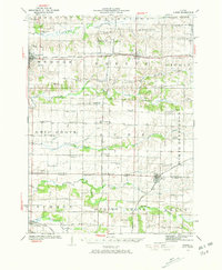
 1925 Galesburg1968 Print · USGSGalesburg and the surrounding Knox County townships appear here as a thriving rail and agricultural center between the world wars. Researchers can trace dozens of rural school sites and early landmarks like Lake Bracken, Orange Chapel, and the East Galesburg Randall PO.2 unique versions available
 - 1927 Map of Galesburg
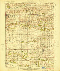
 1927 Galesburg1927 Print · USGSKnox County is captured in the mid-twenties at its peak as a Midwestern rail hub centered on Galesburg. Local historians can trace dozens of rural school sites like Log City School or explore the early footprints of Knoxville and Abingdon.3 unique versions available
End of results
Showing maps 1-6 of 6
Top cities of Warren County
- Monmouth historical maps
- Roseville historical maps
- Kirkwood historical maps
- Greenbush historical maps
- Coldbrook historical maps
- Berwick historical maps
See more
Frequently asked questions
- What are the different types of historical maps available for Warren County?
- What is the oldest map of Warren County?
- Where can I purchase historical maps of Warren County for my home or office?
- Where can I download high-res historical maps of Warren County?
- Are there historical topographic maps available for Warren County?
- Is there historical aerial imagery available for Warren County?
- Where are historical maps of Warren County sourced from?