1980s Maps of Erie, Illinois
Explore 2 historic maps of Erie from the 1980s. These maps offer a rare glimpse into what life looked like during the 1980s — showing old roads, neighborhoods, homes, and landmarks that have changed or disappeared over time.
Whether you're researching your family's past, planning a metal detecting trip, or studying how Erie's landscape evolved across the 1980s, these high-resolution maps are a powerful tool for exploring the history of this region.
- Focus on a specific era: All maps on this page are from the 1980s, giving you a focused view of this time period.
- See what’s changed: Compare century-old streets, trails, and buildings to today's modern landscape using overlays and satellite layers.
- Research with precision: Use these maps for genealogy, historical research, land use analysis, or educational projects.
- View, download, or print: Maps are fully viewable online in high resolution, and can be downloaded or printed for your own records.
Start exploring Erie's history through authentic maps from the 1980s. This is your window into the past.
Erie, IL maps
(2)- 1982 Map of Erie
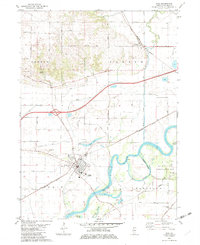 1982 Erie1982 Print · USGSWhiteside County's river-bottom lands are captured here in the early 1980s, centered on the bend of the Rock River. Genealogists and local historians can locate early burial sites like Smack Cem and Sandytown Cem or trace the rural routes connecting Newton Corners and Fenton.
 - 1984 Map of Davenport, 1985 Print
 1984 Davenport1985 Print · USGSThe Quad Cities and the eastern Iowa riverlands are captured in the mid-eighties as industry and conservation converged along the Mississippi. Genealogists and local historians can trace rural roots through Stender Church, Oxford Mills, and the Elmwood Cem burial grounds.2 unique versions available
End of results
Showing maps 1-2 of 2
Top cities near Erie
- Clinton historical maps
- East Moline historical maps
- Geneseo historical maps
- Camanche historical maps
- Morrison historical maps
- Fulton historical maps
See more
Frequently asked questions
- What are the different types of historical maps available for Erie?
- What is the oldest map of Erie?
- Where can I purchase historical maps of Erie for my home or office?
- Where can I download high-res historical maps of Erie?
- Are there historical topographic maps available for Erie?
- Is there historical aerial imagery available for Erie?
- Where are historical maps of Erie sourced from?