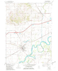
1982 Map of Erie
USGS Topo · Published 1982About this map
Rock River meanders across this Whiteside County landscape, defining the character of the Erie and Portland townships in the early 1980s. The river's influence is evident in the oxbows and wetlands of the Big Bend State Conservation Area and the quiet waters of Hadaway Slough. Settlement patterns are well-established here, with the town of Erie serving as a central hub, flanked by the smaller rural communities of Fenton and Newton Corners. The local economy and history are grounded in the land, shown through the presence of several Gravel Pits and the Burlington Northern railroad lines that cut through the terrain. Significant local landmarks include Mineral Spring and the Smack Cem, providing valuable points of reference for those researching family history or the development of this river-bound region before modern expansions.
Find a feature on this map
55 named features on this map. Tap any name to fly to it.
Don’t see what you’re looking for? This feature index may not catch every label — zoom into the map to look around manually.
Map Details
Editions of this 1982 Erie Map
This is the sole edition of this map. No revisions or reprints were ever made.
Other maps of this area

1891 · Clinton
USGS Topo · 1:62,500

1894 · Clinton
USGS Topo · 1:62,500

1899 · Clinton
USGS Topo · 1:125,000

1932 · Prophetstown
USGS Topo · 1:48,000

1934 · Morrison
USGS Topo · 1:48,000

1936 · Prophetstown
USGS Topo · 1:62,500

1940 · Morrison
USGS Topo · 1:62,500

1952 · Erie
USGS Topo · 1:62,500

1952 · Clinton
USGS Topo · 1:62,500
1953 · Clinton
USGS Topo · 1:24,000