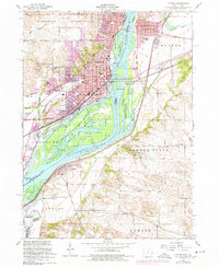
1953 Map of Clinton
USGS Topo · Published 1977About this map
The Mississippi River dominates this mid-century landscape, acting as both a natural boundary and a commercial artery for Clinton, Iowa, and its neighbors across the water in Illinois. The urban layout of Clinton reveals a city deeply connected to its riverfront, from the Municipal Dock to the expansive rail networks of the Chicago and Northwestern and the Chicago Milwaukee St Paul and Pacific. The industrial and civic development is balanced by a massive conservation footprint, most notably the Upper Mississippi River Wildlife and Fish Refuge which spans numerous islands and backwaters like Sunfish Slough. For genealogists and local historians, the map is a dense record of institutional life, documenting numerous schools such as Franklin School and Seymour School, hospitals like Mercy Hospital, and established burial grounds including Springdale Cemetery and Holy Cross Cemetery.
Find a feature on this map
65 named features on this map. Tap any name to fly to it.
Don’t see what you’re looking for? This feature index may not catch every label — zoom into the map to look around manually.
Map Details
Editions of this 1953 Clinton Map
This is the sole edition of this map. No revisions or reprints were ever made.
Other maps of this area

1891 · Clinton
USGS Topo · 1:62,500

1892 · Goose Lake
USGS Topo · 1:62,500

1892 · Leclaire
USGS Topo · 1:62,500

1893 · Leclaire
USGS Topo · 1:62,500

1894 · Goose Lake
USGS Topo · 1:62,500

1894 · Clinton
USGS Topo · 1:62,500

1899 · Clinton
USGS Topo · 1:125,000

1952 · Erie
USGS Topo · 1:62,500

1952 · Clinton
USGS Topo · 1:62,500
1952 · Cordova
USGS Topo · 1:24,000