1950s Maps of Joliet, Illinois
Explore 12 historic maps of Joliet from the 1950s. These maps offer a rare glimpse into what life looked like during the 1950s — showing old roads, neighborhoods, homes, and landmarks that have changed or disappeared over time.
Whether you're researching your family's past, planning a metal detecting trip, or studying how Joliet's landscape evolved across the 1950s, these high-resolution maps are a powerful tool for exploring the history of this region.
- Focus on a specific era: All maps on this page are from the 1950s, giving you a focused view of this time period.
- See what’s changed: Compare century-old streets, trails, and buildings to today's modern landscape using overlays and satellite layers.
- Research with precision: Use these maps for genealogy, historical research, land use analysis, or educational projects.
- View, download, or print: Maps are fully viewable online in high resolution, and can be downloaded or printed for your own records.
Start exploring Joliet's history through authentic maps from the 1950s. This is your window into the past.
Joliet, IL maps
(12)- 1953 Map of Mokena, 1955 Print
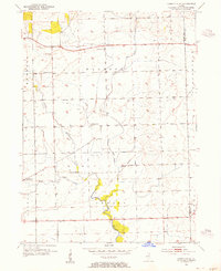
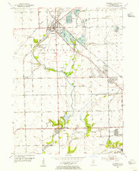
 1953 Mokena1955 Print · USGSWill County's agricultural heartland is captured mid-century as the rail-centered towns of Mokena and New Lenox began to expand. Genealogists and historians can locate numerous rural landmarks, including St Johns Cem, the Wabash railroad, and Wells Corner Sch.
 - 1953 Map of Yorkville SE, 1955 Print
 1953 Yorkville SE1955 Print · USGSIn the early 1950s, the rural border between Kendall and Will counties remained a landscape of family farms and local school districts. Genealogists can locate community landmarks such as Naausay Cem, Marysville Sch, and the village of Plattville.3 unique versions available
 - 1953 Map of Elwood, 1955 Print
 1953 Elwood1955 Print · USGSNear the village of Elwood in the early fifties, the landscape was defined by the massive expansion of the Joliet Arsenal and a heavy rail network. Local historians can trace old schoolhouse sites like Rose Hill Sch and Brown Sch alongside the Old Indian Bdy.3 unique versions available
 - 1953 Map of Chicago, 1964 Print
 1953 Chicago1964 Print · USGSThe southern Lake Michigan shoreline was rapidly modernizing in the mid-fifties, balancing heavy industry with its famous academic centers. Researchers can trace the footprints of Notre Dame University or locate vanished sites like the Kingsbury Ordnance Plant and Meigs Field.5 unique versions available
 - 1954 Map of Joliet, 1955 Print
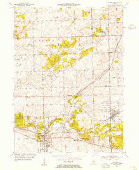
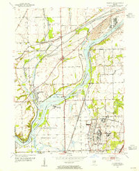
 1954 Joliet1955 Print · USGSThe industrial heart of the Des Plaines River corridor comes alive in the mid-1950s. Trace the complex rail and canal networks through Lockport and Joliet, finding historic landmarks like Stateville State Prison and Lewis College.
 - 1954 Map of Plainfield, 1955 Print
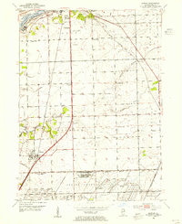
 1954 Plainfield1955 Print · USGSWill County during the mid-fifties reveals a landscape defined by the Du Page River and the bustling industrial corridors of the Elgin Joliet and Eastern Railroad. Researchers can locate family landmarks like Caton Farm, trace historic burials at St Marys Cem, or find early rural schools such as Van Horn Sch.
 - 1954 Map of Channahon, 1955 Print
 1954 Channahon1955 Print · USGSWill County at mid-century reveals a landscape shaped by major river junctions and the legacy of the canal era. Researchers can trace historical property lines and infrastructure through Channahon, finding detail on landmarks like Willard Grove Cem, Smith Bridge, and the Schweizer Sch.4 unique versions available
 - 1954 Map of Yorkville, 1959 Print
 1954 Yorkville1959 Print · USGSKendall County in the mid-1950s shows a balance between growing riverside towns and an expansive agricultural interior. Genealogists can trace family roots through rural landmarks like Naausay Ch, Jericho Cem, and the long-standing diagonal of the Old Indian Boundary.2 unique versions available
 - 1954 Map of Wilmington, 1960 Print
 1954 Wilmington1960 Print · USGSWill and Grundy counties in the mid-fifties show a landscape of industrial convergence where major railroads meet the state's storied canal systems. Researchers can trace the Old Indian Boundary or locate family sites like the Soldiers Widows Home and Willard Grove Cem.3 unique versions available
 - 1954 Map of Joliet, 1960 Print
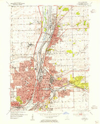
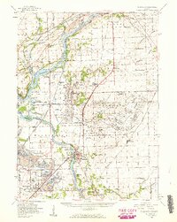
 1954 Joliet1960 Print · USGSMid-century Joliet and Plainfield are captured here during a period of heavy industrial and transit growth. Researchers can trace the alignment of the Lincoln Highway and find localized details like the State Prison Farm and Caton Farm.
 - 1957 Map of Chicago
 1957 Chicago1957 Print · USGSThe industrial heartland and southern Great Lakes shoreline are captured here during the peak of mid-century growth. Researchers can trace the massive Gary Steel Works, the grounds of the University of Notre Dame, and the early paths of the Tri-State Tollway.
 - 1958 Map of Aurora, 1969 Print
 1958 Aurora1969 Print · USGSNorthern Illinois in the late fifties shows a landscape of powerful river industry and expanding transport corridors. Genealogists and historians can trace the development of Aurora and Joliet or locate sites like the Elwood Ordnance Plant and Starved Rock.3 unique versions available
End of results
Showing maps 1-12 of 12
Top cities near Joliet
- Aurora historical maps
- Naperville historical maps
- Bolingbrook historical maps
- Plainfield historical maps
- Romeoville historical maps
- Oswego historical maps
See more
Top neighborhoods of Joliet
- East Joliet historical maps
- Forest Park historical maps
- Raynor Park historical maps
- Idylside historical maps
- Union historical maps
Frequently asked questions
- What are the different types of historical maps available for Joliet?
- What is the oldest map of Joliet?
- Where can I purchase historical maps of Joliet for my home or office?
- Where can I download high-res historical maps of Joliet?
- Are there historical topographic maps available for Joliet?
- Is there historical aerial imagery available for Joliet?
- Where are historical maps of Joliet sourced from?