1990s Maps of Allen County, Indiana
Explore 7 historic maps of Allen County from the 1990s. These maps offer a rare glimpse into what life looked like during the 1990s — showing old roads, neighborhoods, homes, and landmarks that have changed or disappeared over time.
Whether you're researching your family's past, planning a metal detecting trip, or studying how Allen County's landscape evolved across the 1990s, these high-resolution maps are a powerful tool for exploring the history of this region.
- Focus on a specific era: All maps on this page are from the 1990s, giving you a focused view of this time period.
- See what’s changed: Compare century-old streets, trails, and buildings to today's modern landscape using overlays and satellite layers.
- Research with precision: Use these maps for genealogy, historical research, land use analysis, or educational projects.
- View, download, or print: Maps are fully viewable online in high resolution, and can be downloaded or printed for your own records.
Start exploring Allen County's history through authentic maps from the 1990s. This is your window into the past.
Allen County, IN maps
(7)- 1992 Map of Grabill, 1995 Print
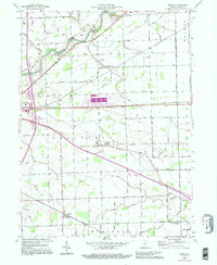
 1992 Grabill1995 Print · USGSNortheast Indiana's agricultural heartland is documented here in the final decade of the twentieth century, showing the established rail and river towns of Allen County. Family historians can locate family-named sites like Barnett Cem and rural centers such as Grabill and Milan Center.
 - 1992 Map of Maples, 1995 Print
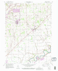
 1992 Maples1995 Print · USGSAllen County in the early 1990s remained a landscape of traditional township grids and small rail-side hamlets. Genealogists and local historians can trace legacy sites like the St Louis Academy, Four Presidents Corners, and the settlement of Maples.
 - 1992 Map of Woodburn South, 1995 Print
 1992 Woodburn South1995 Print · USGSCrossing the Indiana and Ohio border in the 1990s, this area reflects a deeply rooted agricultural and transport landscape. Family historians can trace local landmarks like Sugar Ridge Cem and the Township Sch along the historic Lincoln Highway.
 - 1994 Map of Fort Wayne
 1994 Fort Wayne1994 Print · USGSNortheast Indiana in the mid-nineties shows a landscape deeply tied to its glacial lakes and early rail networks. Genealogists and historians can trace old transit lines like the Old Ind RR and explore lakeside settlements such as Enchanted Hills and Syracuse.
 - 1994 Map of Poe, 1995 Print
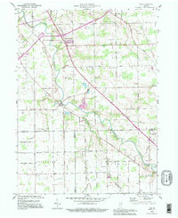 1994 Poe1995 Print · USGSNortheastern Indiana farmland at the close of the twentieth century is captured here as the St Marys River meanders through Allen County. Genealogists can locate family landmarks like Bethel Cem, Scheiman Bridge, and the community of Hoagland in its mid-nineties state.
 - 1998 Map of Fort Wayne West, 2001 Print
 1998 Fort Wayne West2001 Print · USGSFort Wayne's western expansion in the late twentieth century is documented here as urban neighborhoods began to merge with rural townships. Genealogists and local historians can trace family locations through numerous sites like Lindenwood Cemetery, Waynedale, and St Vincents Orphan Home.
 - 1998 Map of Fort Wayne East, 2001 Print
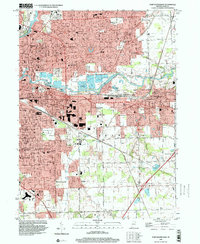 1998 Fort Wayne East2001 Print · USGSFort Wayne and its eastern suburbs are captured here in the late nineties, showcasing the city's significant post-war expansion. Genealogists and local historians can trace residential growth in Anthony Wayne Village or locate landmarks like Concordia Sem and the IOOF Cem.
End of results
Showing maps 1-7 of 7
Top cities of Allen County
- Fort Wayne historical maps
- Aboite historical maps
- New Haven historical maps
- Leo-Cedarville historical maps
- Huntertown historical maps
- Woodburn historical maps
See more
Frequently asked questions
- What are the different types of historical maps available for Allen County?
- What is the oldest map of Allen County?
- Where can I purchase historical maps of Allen County for my home or office?
- Where can I download high-res historical maps of Allen County?
- Are there historical topographic maps available for Allen County?
- Is there historical aerial imagery available for Allen County?
- Where are historical maps of Allen County sourced from?