1930s Maps of Benton County, Indiana
Explore 3 historic maps of Benton County from the 1930s. These maps offer a rare glimpse into what life looked like during the 1930s — showing old roads, neighborhoods, homes, and landmarks that have changed or disappeared over time.
Whether you're researching your family's past, planning a metal detecting trip, or studying how Benton County's landscape evolved across the 1930s, these high-resolution maps are a powerful tool for exploring the history of this region.
- Focus on a specific era: All maps on this page are from the 1930s, giving you a focused view of this time period.
- See what’s changed: Compare century-old streets, trails, and buildings to today's modern landscape using overlays and satellite layers.
- Research with precision: Use these maps for genealogy, historical research, land use analysis, or educational projects.
- View, download, or print: Maps are fully viewable online in high resolution, and can be downloaded or printed for your own records.
Start exploring Benton County's history through authentic maps from the 1930s. This is your window into the past.
Benton County, IN maps
(3)- 1933 Map of Hoopeston
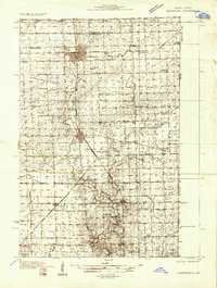 1933 Hoopeston1933 Print · USGSVermilion County and the Illinois-Indiana borderlands are captured here in the early 1930s as a thriving rail and agricultural corridor. Genealogists can locate dozens of rural schools like White Sch and family-linked landmarks such as Ross Cem or Manns Chapel.
 - 1938 Map of Milford
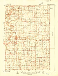 1938 Milford1938 Print · USGSIroquois County at the end of the Depression era is a landscape of thriving rail towns and numerous one-room schoolhouses. Researchers can locate nearly thirty distinct rural schools like White College Sch and Fidelity Sch, along with family burial grounds such as Belmont Cem.
 - 1938 Map of Hoopeston
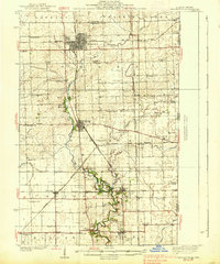 1938 Hoopeston1938 Print · USGSEastern Illinois at the height of the rail era shows a landscape defined by busy junctions and tightly knit rural communities. Genealogists and historians can trace family roots through dozens of local landmarks like Squankum Sch, Rose Cem, and Pleasant View Ch.3 unique versions available
End of results
Showing maps 1-3 of 3
Top cities of Benton County
- Fowler historical maps
- Oxford historical maps
- Boswell historical maps
- Earl Park historical maps
- Ambia historical maps
Frequently asked questions
- What are the different types of historical maps available for Benton County?
- What is the oldest map of Benton County?
- Where can I purchase historical maps of Benton County for my home or office?
- Where can I download high-res historical maps of Benton County?
- Are there historical topographic maps available for Benton County?
- Is there historical aerial imagery available for Benton County?
- Where are historical maps of Benton County sourced from?