1940s Maps of Benton County, Indiana
Explore 2 historic maps of Benton County from the 1940s. These maps offer a rare glimpse into what life looked like during the 1940s — showing old roads, neighborhoods, homes, and landmarks that have changed or disappeared over time.
Whether you're researching your family's past, planning a metal detecting trip, or studying how Benton County's landscape evolved across the 1940s, these high-resolution maps are a powerful tool for exploring the history of this region.
- Focus on a specific era: All maps on this page are from the 1940s, giving you a focused view of this time period.
- See what’s changed: Compare century-old streets, trails, and buildings to today's modern landscape using overlays and satellite layers.
- Research with precision: Use these maps for genealogy, historical research, land use analysis, or educational projects.
- View, download, or print: Maps are fully viewable online in high resolution, and can be downloaded or printed for your own records.
Start exploring Benton County's history through authentic maps from the 1940s. This is your window into the past.
Benton County, IN maps
(2)- 1942 Map of Otterbein
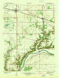 1942 Otterbein1942 Print · USGSIndiana's prairie meets the Wabash River valley at the start of the 1940s, showing a landscape defined by rail lines and early canal history. Genealogists and historians can trace family roots through rural landmarks like Asbury Cem, the Armstrong Chapel, and the community of Green Hill.
 - 1944 Map of Milford
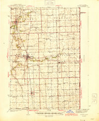 1944 Milford1944 Print · USGSIroquois County at the close of the second World War is a landscape defined by rail junctions and rural schoolhouses. Genealogists can trace family roots through numerous sites like Sugar Creek Chapel, Belmont Cem, and early schools including White College Sch.2 unique versions available
End of results
Showing maps 1-2 of 2
Top cities of Benton County
- Fowler historical maps
- Oxford historical maps
- Boswell historical maps
- Earl Park historical maps
- Ambia historical maps
Frequently asked questions
- What are the different types of historical maps available for Benton County?
- What is the oldest map of Benton County?
- Where can I purchase historical maps of Benton County for my home or office?
- Where can I download high-res historical maps of Benton County?
- Are there historical topographic maps available for Benton County?
- Is there historical aerial imagery available for Benton County?
- Where are historical maps of Benton County sourced from?