1940s Maps of Nashville, Indiana
Explore 4 historic maps of Nashville from the 1940s. These maps offer a rare glimpse into what life looked like during the 1940s — showing old roads, neighborhoods, homes, and landmarks that have changed or disappeared over time.
Whether you're researching your family's past, planning a metal detecting trip, or studying how Nashville's landscape evolved across the 1940s, these high-resolution maps are a powerful tool for exploring the history of this region.
- Focus on a specific era: All maps on this page are from the 1940s, giving you a focused view of this time period.
- See what’s changed: Compare century-old streets, trails, and buildings to today's modern landscape using overlays and satellite layers.
- Research with precision: Use these maps for genealogy, historical research, land use analysis, or educational projects.
- View, download, or print: Maps are fully viewable online in high resolution, and can be downloaded or printed for your own records.
Start exploring Nashville's history through authentic maps from the 1940s. This is your window into the past.
Nashville, IN maps
(4)- 1942 Map of Franklin
 1942 Franklin1942 Print · USGSCentral Indiana during the early years of the war shows a landscape of established rail towns and growing military installations. Genealogists can trace family names across small settlements like Nineveh, Bean Blossom, and Helmsburg, or locate the Indiana University Observatory.
 - 1946 Map of Belmont, 1960 Print
 1946 Belmont1960 Print · USGSMid-century Brown County is captured here at a time when remote ridge-top cemeteries and rural schoolhouses still defined the local geography. Genealogists can locate family sites like Brummet Cem, the T C Steele Memorial, and the West Toll House.2 unique versions available
 - 1947 Map of Nashville, 1960 Print
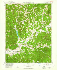
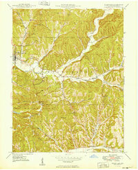
 1947 Nashville1960 Print · USGSBrown County’s intricate ridges and hollows are captured here in the late 1940s, showing the early bounds of the state park and national forest. Researchers can locate vanished landmarks like Clark Sch, the crossroads at Gnaw Bone, and the high point of Weed Patch Hill.
 - 1949 Map of Nashville
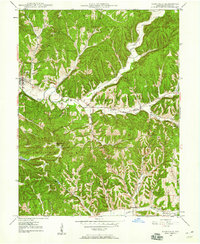
 1949 Nashville1949 Print · USGSNashville and the surrounding Brown County ridges are captured here in the late 1940s. Genealogists can trace family names through landmarks like Seelmaer Hill, local schools such as Mt Liberty Sch, and the unique crossroads of Gnaw Bone.2 unique versions available
End of results
Showing maps 1-4 of 4
Top cities near Nashville
- Columbus historical maps
- Martinsville historical maps
- Nineveh historical maps
- Princes Lakes historical maps
- Trafalgar historical maps
- Morgantown historical maps
Frequently asked questions
- What are the different types of historical maps available for Nashville?
- What is the oldest map of Nashville?
- Where can I purchase historical maps of Nashville for my home or office?
- Where can I download high-res historical maps of Nashville?
- Are there historical topographic maps available for Nashville?
- Is there historical aerial imagery available for Nashville?
- Where are historical maps of Nashville sourced from?