1940s Maps of Clay County, Indiana
Explore 2 historic maps of Clay County from the 1940s. These maps offer a rare glimpse into what life looked like during the 1940s — showing old roads, neighborhoods, homes, and landmarks that have changed or disappeared over time.
Whether you're researching your family's past, planning a metal detecting trip, or studying how Clay County's landscape evolved across the 1940s, these high-resolution maps are a powerful tool for exploring the history of this region.
- Focus on a specific era: All maps on this page are from the 1940s, giving you a focused view of this time period.
- See what’s changed: Compare century-old streets, trails, and buildings to today's modern landscape using overlays and satellite layers.
- Research with precision: Use these maps for genealogy, historical research, land use analysis, or educational projects.
- View, download, or print: Maps are fully viewable online in high resolution, and can be downloaded or printed for your own records.
Start exploring Clay County's history through authentic maps from the 1940s. This is your window into the past.
Clay County, IN maps
(2)- 1940 Map of Jasonville
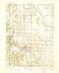 1940 Jasonville1940 Print · USGSJasonville and the surrounding coalfields are captured in the late 1930s, showing a landscape defined by industry and rural community. Genealogists can locate family landmarks like Sanderson Cem, Little Flock Ch, and Listen Sch.2 unique versions available
 - 1948 Map of Coal City
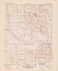 1948 Coal City1948 Print · USGSThe rural borderlands of Owen, Clay, and Greene Counties are shown here during the late 1940s, showcasing a landscape shaped by coal mining and transport. Researchers can trace the path of the Wabash and Erie Canal (Abandoned) and locate vanished landmarks like Stockton, Sink Cem, and the College Hill Sch.2 unique versions available
End of results
Showing maps 1-2 of 2
Top cities of Clay County
- Brazil historical maps
- Clay City historical maps
- Knightsville historical maps
- Harmony historical maps
- Staunton historical maps
- Carbon historical maps
See more
Frequently asked questions
- What are the different types of historical maps available for Clay County?
- What is the oldest map of Clay County?
- Where can I purchase historical maps of Clay County for my home or office?
- Where can I download high-res historical maps of Clay County?
- Are there historical topographic maps available for Clay County?
- Is there historical aerial imagery available for Clay County?
- Where are historical maps of Clay County sourced from?