1960s Maps of Clay County, Indiana
Explore 6 historic maps of Clay County from the 1960s. These maps offer a rare glimpse into what life looked like during the 1960s — showing old roads, neighborhoods, homes, and landmarks that have changed or disappeared over time.
Whether you're researching your family's past, planning a metal detecting trip, or studying how Clay County's landscape evolved across the 1960s, these high-resolution maps are a powerful tool for exploring the history of this region.
- Focus on a specific era: All maps on this page are from the 1960s, giving you a focused view of this time period.
- See what’s changed: Compare century-old streets, trails, and buildings to today's modern landscape using overlays and satellite layers.
- Research with precision: Use these maps for genealogy, historical research, land use analysis, or educational projects.
- View, download, or print: Maps are fully viewable online in high resolution, and can be downloaded or printed for your own records.
Start exploring Clay County's history through authentic maps from the 1960s. This is your window into the past.
Clay County, IN maps
(6)- 1960 Map of Brazil East
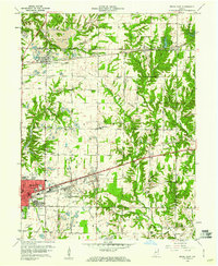 1960 Brazil East1960 Print · USGSClay County at the dawn of the 1960s shows a landscape of busy coal pits and industrial towns. Genealogists and historians can trace family locations near Knightsville, search for burials at Calcutta Cem, or follow the path of the Pennsylvania Railroad.3 unique versions available
 - 1960 Map of Brazil West, 1961 Print
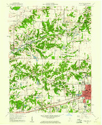 1960 Brazil West1961 Print · USGSThe coal country of Clay and Vigo counties is captured here in the early sixties, showing an era of intensive strip mining and rail transport. Genealogists can locate family names at Cottage Hill Cem and Archer Cem or trace vanished rail stops like Cobb and Billville.3 unique versions available
 - 1962 Map of Indianapolis
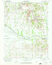
 1962 Indianapolis1962 Print · USGSCentral Indiana and the Illinois borderlands are captured here in the early sixties, showing the region's dense rail networks and growing urban centers. Genealogists and historians can locate family-named landmarks and institutions like Crown Hill Cem, Indiana University, and the Indianapolis Motor Speedway.
 - 1963 Map of Coal City, 1964 Print
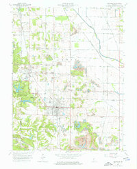
 1963 Coal City1964 Print · USGSIndiana's western coal country is revealed in the early 1960s as a landscape of extraction and deep local roots. You can trace the New York Central rail line through Coal City or find family history at Winters Cem and the New Hope Ch.4 unique versions available
 - 1963 Map of Jasonville, 1965 Print
 1963 Jasonville1965 Print · USGSThe coalfields of western Indiana are in full operation during the early sixties, centered on the rail-heavy hub of Jasonville. Researchers can trace the path of the historic Wabash and Erie Canal or locate local landmarks like Friendly Grove Ch and Oak Grove Cem.5 unique versions available
 - 1963 Map of Clay City, 1987 Print
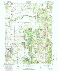 1963 Clay City1987 Print · USGSClay City and the surrounding townships are documented here during a period of steady rural character in the 1960s. Researchers can trace numerous country burial grounds and congregational sites like Red Brush Cem Ch, Goshorn Memorial Park, and Cole Cem.
End of results
Showing maps 1-6 of 6
Top cities of Clay County
- Brazil historical maps
- Clay City historical maps
- Knightsville historical maps
- Harmony historical maps
- Staunton historical maps
- Carbon historical maps
See more
Frequently asked questions
- What are the different types of historical maps available for Clay County?
- What is the oldest map of Clay County?
- Where can I purchase historical maps of Clay County for my home or office?
- Where can I download high-res historical maps of Clay County?
- Are there historical topographic maps available for Clay County?
- Is there historical aerial imagery available for Clay County?
- Where are historical maps of Clay County sourced from?