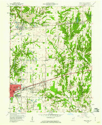
1960 Map of Brazil East
USGS Topo · Published 1960About this map
Coal extraction and heavy rail transport define this 1960 revision of the landscape east of Brazil. The terrain is significantly altered by extensive Strip Mine and Strip Mine operations that flank the established towns and transportation corridors. These industrial zones press right up against settlements like Carbon, Knightsville, and Harmony, illustrating the intense reliance on the local mineral resources. The transportation network is anchored by the Pennsylvania Railroad and New York Central railroads, which facilitated the movement of goods from local Kilns and a large Granary. Genealogists will find a wealth of local burial sites, including Calcutta Cem, Redman Cem, and Pell Cem, often situated near rural congregations like Mt Lebanon Ch and Ebenezer Ch. The presence of the Treaty Line provides a historical boundary reference amidst the evolving suburban and industrial growth near the Courthouse and the eastern edge of Brazil.
Find a feature on this map
55 named features on this map. Tap any name to fly to it.
Don’t see what you’re looking for? This feature index may not catch every label — zoom into the map to look around manually.
Map Details
Editions of this 1960 Brazil East Map
3 editions found
Other maps of this area

1908 · Clay City
USGS Topo · 1:48,000

1910 · Clay City
USGS Topo · 1:62,500

1950 · Brazil East
USGS Topo · 1:24,000

1950 · Brazil West
USGS Topo · 1:24,000

1951 · Clinton Falls
USGS Topo · 1:24,000

1951 · Mansfield
USGS Topo · 1:24,000

1952 · Catlin
USGS Topo · 1:24,000

1952 · Reelsville
USGS Topo · 1:24,000

1953 · Indianapolis
USGS Topo · 1:250,000

1956 · Indianapolis
USGS Topo · 1:250,000