1940s Maps of Leavenworth, Indiana
Explore 2 historic maps of Leavenworth from the 1940s. These maps offer a rare glimpse into what life looked like during the 1940s — showing old roads, neighborhoods, homes, and landmarks that have changed or disappeared over time.
Whether you're researching your family's past, planning a metal detecting trip, or studying how Leavenworth's landscape evolved across the 1940s, these high-resolution maps are a powerful tool for exploring the history of this region.
- Focus on a specific era: All maps on this page are from the 1940s, giving you a focused view of this time period.
- See what’s changed: Compare century-old streets, trails, and buildings to today's modern landscape using overlays and satellite layers.
- Research with precision: Use these maps for genealogy, historical research, land use analysis, or educational projects.
- View, download, or print: Maps are fully viewable online in high resolution, and can be downloaded or printed for your own records.
Start exploring Leavenworth's history through authentic maps from the 1940s. This is your window into the past.
Leavenworth, IN maps
(2)- 1946 Map of Leavenworth
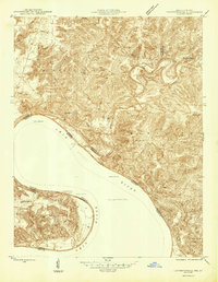 1946 Leavenworth1946 Print · USGSThe Indiana-Kentucky borderlands come into focus in the mid-1940s as the river economy of the Ohio Valley transitions toward modern infrastructure. Trace family homesteads and local history through rural anchors like Blue River Chapel, Sunshine Sch, and the riverside community of Leavenworth.
 - 1947 Map of Leavenworth
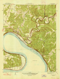 1947 Leavenworth1947 Print · USGSSouthern Indiana and northern Kentucky are captured here in the late 1940s as the Ohio River trade still defined life in these border counties. Researchers can locate vanished landmarks like Schooner Point Landing and the rural Precinct Sch or explore the early environs of Wyandotte Cave.2 unique versions available
End of results
Showing maps 1-2 of 2
Top cities near Leavenworth
- Corydon historical maps
- Brandenburg historical maps
- Marengo historical maps
- Palmyra historical maps
- English historical maps
- Fredericksburg historical maps
See more
Frequently asked questions
- What are the different types of historical maps available for Leavenworth?
- What is the oldest map of Leavenworth?
- Where can I purchase historical maps of Leavenworth for my home or office?
- Where can I download high-res historical maps of Leavenworth?
- Are there historical topographic maps available for Leavenworth?
- Is there historical aerial imagery available for Leavenworth?
- Where are historical maps of Leavenworth sourced from?