Old Maps of Leavenworth, Indiana for Genealogy
Trace your family roots with 16 historic maps of Leavenworth. These high-res maps reveal old neighborhoods, homesites, landmarks, and streets — helping you uncover where your ancestors lived and how the area evolved over time.
- Explore historic neighborhoods: Identify where your relatives may have lived in the 1800s or 1900s.
- Compare maps over time: Trace the changes in streets, buildings, and landmarks for multi-generational research.
- Perfect for genealogy & ancestry research: Used by family historians and researchers to map out lineage and migration.
These maps are an incredible resource for exploring your personal connection to Leavenworth's past.
Leavenworth, IN maps
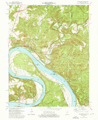
(16)- 1946 Map of Leavenworth
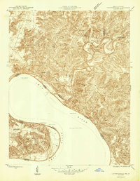 1946 Leavenworth1946 Print · USGSThe Indiana-Kentucky borderlands come into focus in the mid-1940s as the river economy of the Ohio Valley transitions toward modern infrastructure. Trace family homesteads and local history through rural anchors like Blue River Chapel, Sunshine Sch, and the riverside community of Leavenworth.
 - 1947 Map of Leavenworth
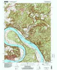
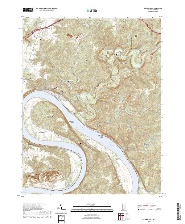
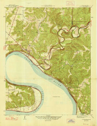 1947 Leavenworth1947 Print · USGSSouthern Indiana and northern Kentucky are captured here in the late 1940s as the Ohio River trade still defined life in these border counties. Researchers can locate vanished landmarks like Schooner Point Landing and the rural Precinct Sch or explore the early environs of Wyandotte Cave.2 unique versions available
 - 1950 Map of Leavenworth, 1954 Print
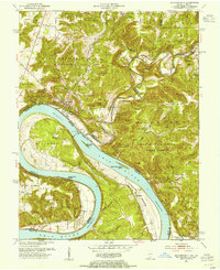 1950 Leavenworth1954 Print · USGSThe Ohio River meanders through Crawford County in the mid-century, showcasing a landscape of dramatic river bends and timbered highlands. Genealogists and local historians can trace family locations near Mt Hope Ch, Peckenpaugh Sch, or the riverside settlement of Leavenworth.3 unique versions available
 - 1950 Map of Alton, 1959 Print
 1950 Alton1959 Print · USGSThe Ohio River loops through the Indiana and Kentucky borderlands at mid-century, following the deep curves of Big Bend and Oxbow Bend. Genealogists and local historians can trace family roots through numerous rural landmarks like St Theresa Academy, Beechland Sch, and the historic town of Leavenworth.2 unique versions available
 - 1956 Map of Vincennes, 1967 Print
 1956 Vincennes1967 Print · USGSSouthern Indiana and the Illinois borderlands are captured here in the mid-fifties, showing the region's dense network of river towns and rail lines. Researchers can trace historic river crossings along the Wabash River or locate landmarks like Wyandotte Cave and Lincoln State Park.4 unique versions available
 - 1957 Map of Vincennes
 1957 Vincennes1957 Print · USGSSouthwest Indiana and the Illinois borderlands come alive in the late 1950s, a period of heavy rail traffic and expanding state forests. Genealogists and historians can trace the riverfronts and rail lines of Vincennes, New Harmony, and the vast Crane Naval Ammunition Depot.
 - 1958 Map of Vincennes
 1958 Vincennes1958 Print · USGSSouthern Indiana and the Illinois borderlands are captured during a mid-century period of heavy rail traffic and military activity. Researchers can trace the sprawling bounds of the Crane Naval Ammunition Depot or locate historic settlements like New Harmony and French Lick.2 unique versions available
 - 1970 Map of Leavenworth, 1972 Print
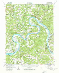
 1970 Leavenworth1972 Print · USGSThe Ohio River valley near the Crawford and Harrison county line is captured here in the early seventies, centered on the historic river town of Leavenworth. Genealogists and hikers can trace old family burial sites like Mt Hope Ch Cem or explore landmarks such as Wyandotte Cave and the landing at Schooner Point Landing.3 unique versions available
 - 1986 Map of Jasper
 1986 Jasper1986 Print · USGSSouthern Indiana in the 1980s is defined by the expansive Patoka Lake and the dense timber of the Hoosier National Forest. Researchers can trace the Southern RR through the hills or locate historic sites like Saint Meinrad and Sulphur Springs.
 - 1994 Map of Jasper
 1994 Jasper1994 Print · USGSSouthern Indiana and the Kentucky borderlands are captured here in the mid-nineties, showing a landscape defined by the Ohio River and dense state forests. Genealogists can locate family landmarks like Saint Meinrad Archabbey, Saint Anthony, and the historic Lincoln Boyhood National Memorial.
 - 1998 Map of Leavenworth, 2001 Print
 1998 Leavenworth2001 Print · USGSThe Indiana-Kentucky borderlands along the Ohio River are captured here at the end of the millennium, showing the transition from the riverbanks to the wooded uplands. Trace the historic movement of the community from Old Leavenworth to the modern town, or locate riverfront sites like Schooner Point Landing and Cape Sandy.
 - 2012 Map of Leavenworth, 2012 Print
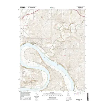
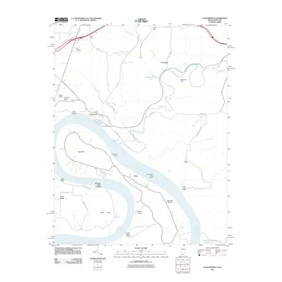 2012 Leavenworth2012 Print · USGSCovers Leavenworth, including Artist Point, Cape Sandy, and other nearby areas
 - 2013 Map of Leavenworth, 2013 Print
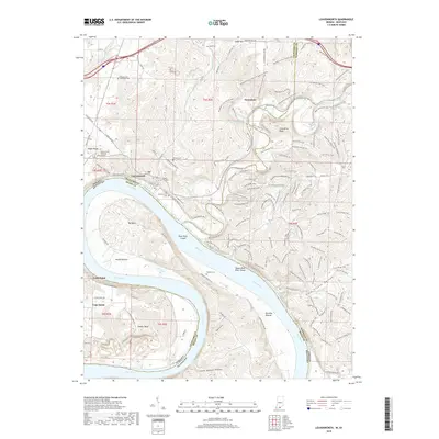
 2013 Leavenworth2013 Print · USGSCovers Leavenworth, including Artist Point, Cape Sandy, and other nearby areas
 - 2016 Map of Leavenworth, 2016 Print
 2016 Leavenworth2016 Print · USGSCovers Leavenworth, including Artist Point, Cape Sandy, and other nearby areas
 - 2019 Map of Leavenworth, 2019 Print
 2019 Leavenworth2019 Print · USGSCovers Leavenworth, including Artist Point, Cape Sandy, and other nearby areas
 - 2022 Map of Leavenworth, 2022 Print
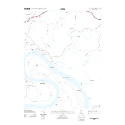
 2022 Leavenworth2022 Print · USGSThe Indiana-Kentucky borderlands along the Ohio River come to life here during the early twenty-first century. Genealogists and local historians can trace family roots at the Foster Family Cemetery or explore the river bottoms of Round Bottom and Paradise Bottom.
End of results
Showing maps 1-16 of 16
Top cities near Leavenworth
- Corydon historical maps
- Brandenburg historical maps
- Marengo historical maps
- Palmyra historical maps
- English historical maps
- Fredericksburg historical maps
See more
Frequently asked questions
- What are the different types of historical maps available for Leavenworth?
- What is the oldest map of Leavenworth?
- Where can I purchase historical maps of Leavenworth for my home or office?
- Where can I download high-res historical maps of Leavenworth?
- Are there historical topographic maps available for Leavenworth?
- Is there historical aerial imagery available for Leavenworth?
- Where are historical maps of Leavenworth sourced from?