1980s Maps of Floyd County, Indiana
Explore 6 historic maps of Floyd County from the 1980s. These maps offer a rare glimpse into what life looked like during the 1980s — showing old roads, neighborhoods, homes, and landmarks that have changed or disappeared over time.
Whether you're researching your family's past, planning a metal detecting trip, or studying how Floyd County's landscape evolved across the 1980s, these high-resolution maps are a powerful tool for exploring the history of this region.
- Focus on a specific era: All maps on this page are from the 1980s, giving you a focused view of this time period.
- See what’s changed: Compare century-old streets, trails, and buildings to today's modern landscape using overlays and satellite layers.
- Research with precision: Use these maps for genealogy, historical research, land use analysis, or educational projects.
- View, download, or print: Maps are fully viewable online in high resolution, and can be downloaded or printed for your own records.
Start exploring Floyd County's history through authentic maps from the 1980s. This is your window into the past.
Floyd County, IN maps
(6)- 1982 Map of New Albany
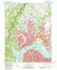 1982 New Albany1982 Print · USGSNew Albany and Louisville face one another across the Ohio River during a period of significant industrial and suburban expansion. Genealogists and historians can trace family sites among numerous landmarks like Blackiston Mill, Fairview Cem, and the Indiana University Southeast Campus.2 unique versions available
 - 1982 Map of Lanesville
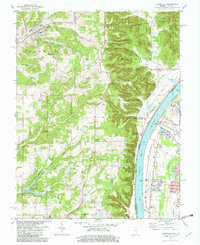 1982 Lanesville1982 Print · USGSHarrison County and the Ohio River shoreline are captured here in the early 1980s as rural crossroads and riverside settlements thrived. Family historians can trace local roots at Lanesville Cem, Lottick Corner, and St Johns Ch.2 unique versions available
 - 1983 Map of Louisville West, 1984 Print
 1983 Louisville West1984 Print · USGSGreater Louisville and its southwestern neighborhoods are shown here just after the post-war suburban boom transformed the landscape. Researchers can trace historic family burial sites at St Stephens Cem or locate community anchors like Simmons University and the U S Naval Ordnance Plant.3 unique versions available
 - 1985 Map of Lanesville, 1993 Print
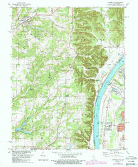 1985 Lanesville1993 Print · USGSThe Indiana bluffs and Kentucky riverbank are captured here during the mid-1980s, showcasing the transition from upland ridges to the industrial river corridor. Genealogists can trace family landmarks like Lanesville Cem, Heistand Cem, and the parish at St Johns Ch.
 - 1986 Map of Jasper
 1986 Jasper1986 Print · USGSSouthern Indiana in the 1980s is defined by the expansive Patoka Lake and the dense timber of the Hoosier National Forest. Researchers can trace the Southern RR through the hills or locate historic sites like Saint Meinrad and Sulphur Springs.
 - 1986 Map of Louisville
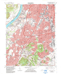
 1986 Louisville1986 Print · USGSMid-1980s Louisville and southern Indiana are shown here during a decade of significant suburban growth and infrastructure development. Researchers can trace the layout of Cave Hill Cemetery, the expansion of Standiford Field, and industrial sites like the Indiana Army Ammunition Plant.2 unique versions available
End of results
Showing maps 1-6 of 6
Top cities of Floyd County
Frequently asked questions
- What are the different types of historical maps available for Floyd County?
- What is the oldest map of Floyd County?
- Where can I purchase historical maps of Floyd County for my home or office?
- Where can I download high-res historical maps of Floyd County?
- Are there historical topographic maps available for Floyd County?
- Is there historical aerial imagery available for Floyd County?
- Where are historical maps of Floyd County sourced from?