1930s Maps of Floyd County, Indiana
Explore 3 historic maps of Floyd County from the 1930s. These maps offer a rare glimpse into what life looked like during the 1930s — showing old roads, neighborhoods, homes, and landmarks that have changed or disappeared over time.
Whether you're researching your family's past, planning a metal detecting trip, or studying how Floyd County's landscape evolved across the 1930s, these high-resolution maps are a powerful tool for exploring the history of this region.
- Focus on a specific era: All maps on this page are from the 1930s, giving you a focused view of this time period.
- See what’s changed: Compare century-old streets, trails, and buildings to today's modern landscape using overlays and satellite layers.
- Research with precision: Use these maps for genealogy, historical research, land use analysis, or educational projects.
- View, download, or print: Maps are fully viewable online in high resolution, and can be downloaded or printed for your own records.
Start exploring Floyd County's history through authentic maps from the 1930s. This is your window into the past.
Floyd County, IN maps
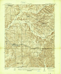
(3)- 1938 Map of Speed
 1938 Speed1938 Print · USGSSouthern Indiana was a busy junction of steam and electric rail at the close of the 1930s. Researchers can trace the dual paths of the Pennsylvania Railroad and Indiana Railroad (Electric) through Sellersburg, Speed, and Memphis.
 - 1939 Map of New Albany
 1939 New Albany1939 Print · USGSThe industrial riverfront of southern Indiana comes alive in this pre-war survey of the Ohio River bend. Genealogists and historians can trace the early footprints of New Albany and Clarksville, locating the County Infirmary, St Marys Cem, and the massive Jeffersonville Military Reservation.
 - 1939 Map of Georgetown
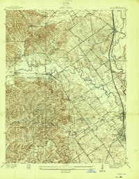
 1939 Georgetown1939 Print · USGSSouthern Indiana's Floyd County highlands are captured here in the late 1930s, showing the early road and rail networks before modern expansion. Genealogists and local historians can trace family roots through Swartz Cem, Salem Ch, and the landmark Mt St Francis Seminary.
End of results
Showing maps 1-3 of 3
Top cities of Floyd County
Frequently asked questions
- What are the different types of historical maps available for Floyd County?
- What is the oldest map of Floyd County?
- Where can I purchase historical maps of Floyd County for my home or office?
- Where can I download high-res historical maps of Floyd County?
- Are there historical topographic maps available for Floyd County?
- Is there historical aerial imagery available for Floyd County?
- Where are historical maps of Floyd County sourced from?