1990s Maps of Floyd County, Indiana
Explore 3 historic maps of Floyd County from the 1990s. These maps offer a rare glimpse into what life looked like during the 1990s — showing old roads, neighborhoods, homes, and landmarks that have changed or disappeared over time.
Whether you're researching your family's past, planning a metal detecting trip, or studying how Floyd County's landscape evolved across the 1990s, these high-resolution maps are a powerful tool for exploring the history of this region.
- Focus on a specific era: All maps on this page are from the 1990s, giving you a focused view of this time period.
- See what’s changed: Compare century-old streets, trails, and buildings to today's modern landscape using overlays and satellite layers.
- Research with precision: Use these maps for genealogy, historical research, land use analysis, or educational projects.
- View, download, or print: Maps are fully viewable online in high resolution, and can be downloaded or printed for your own records.
Start exploring Floyd County's history through authentic maps from the 1990s. This is your window into the past.
Floyd County, IN maps
(3)- 1992 Map of New Albany, 1995 Print
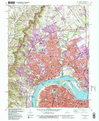 1992 New Albany1995 Print · USGSThe Ohio River corridor comes alive in the early 1990s as it connects New Albany and Clarksville with Louisville. Researchers can trace historic river navigation through McAlpine Locks or locate family sites at Fairview Cem and Blackiston Mill.2 unique versions available
 - 1994 Map of Jasper
 1994 Jasper1994 Print · USGSSouthern Indiana and the Kentucky borderlands are captured here in the mid-nineties, showing a landscape defined by the Ohio River and dense state forests. Genealogists can locate family landmarks like Saint Meinrad Archabbey, Saint Anthony, and the historic Lincoln Boyhood National Memorial.
 - 1998 Map of Louisville West, 2000 Print
 1998 Louisville West2000 Print · USGSThe western reaches of Louisville and the Ohio River shoreline appear here at the close of the century. Local historians can trace neighborhood growth through parish schools and landmarks like Churchill Downs, Waverly Hills, and Iroquois Park.
End of results
Showing maps 1-3 of 3
Top cities of Floyd County
Frequently asked questions
- What are the different types of historical maps available for Floyd County?
- What is the oldest map of Floyd County?
- Where can I purchase historical maps of Floyd County for my home or office?
- Where can I download high-res historical maps of Floyd County?
- Are there historical topographic maps available for Floyd County?
- Is there historical aerial imagery available for Floyd County?
- Where are historical maps of Floyd County sourced from?