1910s Maps of Franklin County, Indiana
Explore 3 historic maps of Franklin County from the 1910s. These maps offer a rare glimpse into what life looked like during the 1910s — showing old roads, neighborhoods, homes, and landmarks that have changed or disappeared over time.
Whether you're researching your family's past, planning a metal detecting trip, or studying how Franklin County's landscape evolved across the 1910s, these high-resolution maps are a powerful tool for exploring the history of this region.
- Focus on a specific era: All maps on this page are from the 1910s, giving you a focused view of this time period.
- See what’s changed: Compare century-old streets, trails, and buildings to today's modern landscape using overlays and satellite layers.
- Research with precision: Use these maps for genealogy, historical research, land use analysis, or educational projects.
- View, download, or print: Maps are fully viewable online in high resolution, and can be downloaded or printed for your own records.
Start exploring Franklin County's history through authentic maps from the 1910s. This is your window into the past.
Franklin County, IN maps
(3)- 1915 Map of College Corner
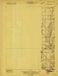 1915 College Corner1915 Print · USGSThe Indiana-Ohio borderlands at the start of the twentieth century are defined here by rail hubs and rural townships. Trace family roots and vanished landmarks near College Corner, Concord Church, and the winding Fourmile Creek.
 - 1915 Map of Harrison
 1915 Harrison1915 Print · USGSThe Indiana-Ohio borderlands come into focus during the mid-teens, showing a landscape of river-valley settlements and rural school districts. Genealogists can locate family landmarks like Vannatta School, Davis School, and the village of Okeana along the Dry Fork.
 - 1918 Map of College Corner
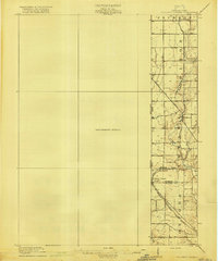 1918 College Corner1918 Print · USGSThe Indiana-Ohio borderlands come into focus during the Great War era, showing the intersection of rail and road commerce. Genealogists and historians can trace the early layout of College Corner, the grounds of Tallawanda Springs, and rural landmarks like School No 3.4 unique versions available
End of results
Showing maps 1-3 of 3
Top cities of Franklin County
- Brookville historical maps
- Blooming Grove historical maps
- Oldenburg historical maps
- Laurel historical maps
- Bath historical maps
- Metamora historical maps
See more
Frequently asked questions
- What are the different types of historical maps available for Franklin County?
- What is the oldest map of Franklin County?
- Where can I purchase historical maps of Franklin County for my home or office?
- Where can I download high-res historical maps of Franklin County?
- Are there historical topographic maps available for Franklin County?
- Is there historical aerial imagery available for Franklin County?
- Where are historical maps of Franklin County sourced from?