1960s Maps of Franklin County, Indiana
Explore 4 historic maps of Franklin County from the 1960s. These maps offer a rare glimpse into what life looked like during the 1960s — showing old roads, neighborhoods, homes, and landmarks that have changed or disappeared over time.
Whether you're researching your family's past, planning a metal detecting trip, or studying how Franklin County's landscape evolved across the 1960s, these high-resolution maps are a powerful tool for exploring the history of this region.
- Focus on a specific era: All maps on this page are from the 1960s, giving you a focused view of this time period.
- See what’s changed: Compare century-old streets, trails, and buildings to today's modern landscape using overlays and satellite layers.
- Research with precision: Use these maps for genealogy, historical research, land use analysis, or educational projects.
- View, download, or print: Maps are fully viewable online in high resolution, and can be downloaded or printed for your own records.
Start exploring Franklin County's history through authentic maps from the 1960s. This is your window into the past.
Franklin County, IN maps
(4)- 1960 Map of College Corner, 1961 Print
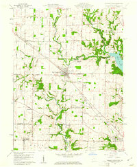 1960 College Corner1961 Print · USGSCollege Corner sits at the crossroads of Indiana and Ohio at the start of the 1960s, a landscape defined by intersecting railroads and state lines. Genealogists can trace family roots through College Corner Cemetery, Hopewell Ch, and the rural settlement of Charlottesville.4 unique versions available
 - 1960 Map of Fairfield, 1962 Print
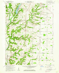 1960 Fairfield1962 Print · USGSThe Whitewater River valley in the early sixties remains a landscape of covered bridges and dispersed farmsteads before major modern changes. Genealogists can trace family footprints at Old Bath Springs Cem, the community of Fairfield, and several rural churches like Salem Ch.2 unique versions available
 - 1961 Map of Batesville, 1963 Print
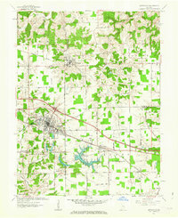 1961 Batesville1963 Print · USGSBatesville and the surrounding Ripley County countryside are captured here in the early sixties, showing a landscape defined by its German Catholic heritage and rail connections. Researchers can locate family landmarks like Holy Family Ch, St Marys Cem, and the rural junction of Cross Roads.5 unique versions available
 - 1961 Map of New Point, 1963 Print
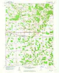 1961 New Point1963 Print · USGSSoutheastern Indiana's agricultural heartland is documented here in the early sixties, centered on the railroad town of New Point. Researchers can trace the New York Central line through Rossburg and locate rural landmarks like Zion Ch and Enochsburg.4 unique versions available
End of results
Showing maps 1-4 of 4
Top cities of Franklin County
- Brookville historical maps
- Blooming Grove historical maps
- Oldenburg historical maps
- Laurel historical maps
- Bath historical maps
- Metamora historical maps
See more
Frequently asked questions
- What are the different types of historical maps available for Franklin County?
- What is the oldest map of Franklin County?
- Where can I purchase historical maps of Franklin County for my home or office?
- Where can I download high-res historical maps of Franklin County?
- Are there historical topographic maps available for Franklin County?
- Is there historical aerial imagery available for Franklin County?
- Where are historical maps of Franklin County sourced from?