1930s Maps of Greene County, Indiana
Explore 3 historic maps of Greene County from the 1930s. These maps offer a rare glimpse into what life looked like during the 1930s — showing old roads, neighborhoods, homes, and landmarks that have changed or disappeared over time.
Whether you're researching your family's past, planning a metal detecting trip, or studying how Greene County's landscape evolved across the 1930s, these high-resolution maps are a powerful tool for exploring the history of this region.
- Focus on a specific era: All maps on this page are from the 1930s, giving you a focused view of this time period.
- See what’s changed: Compare century-old streets, trails, and buildings to today's modern landscape using overlays and satellite layers.
- Research with precision: Use these maps for genealogy, historical research, land use analysis, or educational projects.
- View, download, or print: Maps are fully viewable online in high resolution, and can be downloaded or printed for your own records.
Start exploring Greene County's history through authentic maps from the 1930s. This is your window into the past.
Greene County, IN maps
(3)- 1935 Map of Oolitic
 1935 Oolitic1935 Print · USGSLawrence and Greene Counties are captured in the mid-1930s during a period of heavy limestone production and rural transition. Local historians can trace family roots through numerous country landmarks like Popcorn Church, Williams Bridge, and the Dark Hollow stone works.6 unique versions available
 - 1938 Map of Coal City
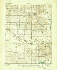 1938 Coal City1938 Print · USGSSouthern Indiana at the end of the 1930s shows a landscape of small coal-mining towns and rural crossroads between the forks of the Eel River. Researchers can trace the path of the Wabash and Erie Canal and locate family roots at Coal City, Sink Cem, or Scaffold Prairie Ch.
 - 1938 Map of Switz City
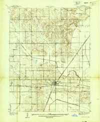 1938 Switz City1938 Print · USGSIn the late 1930s, Switz City functioned as a vital Indiana rail hub where two major lines crossed amidst a landscape shaped by drainage canals. Researchers can locate numerous family burial sites like Bohley Cem or trace early industry at a Coal Mine.
End of results
Showing maps 1-3 of 3
Top cities of Greene County
- Linton historical maps
- Bloomfield historical maps
- Jasonville historical maps
- Worthington historical maps
- Lyons historical maps
- Switz City historical maps
See more
Frequently asked questions
- What are the different types of historical maps available for Greene County?
- What is the oldest map of Greene County?
- Where can I purchase historical maps of Greene County for my home or office?
- Where can I download high-res historical maps of Greene County?
- Are there historical topographic maps available for Greene County?
- Is there historical aerial imagery available for Greene County?
- Where are historical maps of Greene County sourced from?