1970s Maps of Greene County, Indiana
Explore 4 historic maps of Greene County from the 1970s. These maps offer a rare glimpse into what life looked like during the 1970s — showing old roads, neighborhoods, homes, and landmarks that have changed or disappeared over time.
Whether you're researching your family's past, planning a metal detecting trip, or studying how Greene County's landscape evolved across the 1970s, these high-resolution maps are a powerful tool for exploring the history of this region.
- Focus on a specific era: All maps on this page are from the 1970s, giving you a focused view of this time period.
- See what’s changed: Compare century-old streets, trails, and buildings to today's modern landscape using overlays and satellite layers.
- Research with precision: Use these maps for genealogy, historical research, land use analysis, or educational projects.
- View, download, or print: Maps are fully viewable online in high resolution, and can be downloaded or printed for your own records.
Start exploring Greene County's history through authentic maps from the 1970s. This is your window into the past.
Greene County, IN maps
(4)- 1975 Map of Owensburg, 1976 Print
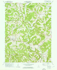 1975 Owensburg1976 Print · USGSSouthern Indiana's rural hills and hollows are documented here during the mid-seventies, showing the intersection of local life and federal land use. Researchers can trace family roots through numerous sites like Dishman Cem or explore the geography of Popcorn and Owensburg.2 unique versions available
 - 1978 Map of Koleen, 1979 Print
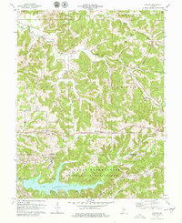 1978 Koleen1979 Print · USGSSouthern Indiana at the end of the seventies shows a mix of rural tradition and federal land use near the Martin and Greene county line. Researchers can trace historic family burial sites like Duke Cem or locate the sprawling Lake Greenwood within the Naval Weapons Support Center.2 unique versions available
 - 1978 Map of Lyons, 1979 Print
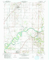 1978 Lyons1979 Print · USGSSouthern Indiana river country is meticulously documented in the late seventies, centered on the White River and the rural communities of Lyons and Newberry. Genealogists and historians can trace old family burial grounds like Slinkard Cem and Bogard Cem or the rail junctions at Bushrod and Beehunter.2 unique versions available
 - 1979 Map of Scotland
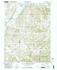 1979 Scotland1979 Print · USGSSouthern Greene County is captured here in the late seventies, showing the junction of agricultural creek bottoms and large-scale military infrastructure. Researchers can trace family history through sites like Gilbreath Cem, Mineral City, and the Antioch Ch.3 unique versions available
End of results
Showing maps 1-4 of 4
Top cities of Greene County
- Linton historical maps
- Bloomfield historical maps
- Jasonville historical maps
- Worthington historical maps
- Lyons historical maps
- Switz City historical maps
See more
Frequently asked questions
- What are the different types of historical maps available for Greene County?
- What is the oldest map of Greene County?
- Where can I purchase historical maps of Greene County for my home or office?
- Where can I download high-res historical maps of Greene County?
- Are there historical topographic maps available for Greene County?
- Is there historical aerial imagery available for Greene County?
- Where are historical maps of Greene County sourced from?