1960s Maps of Greene County, Indiana
Explore 7 historic maps of Greene County from the 1960s. These maps offer a rare glimpse into what life looked like during the 1960s — showing old roads, neighborhoods, homes, and landmarks that have changed or disappeared over time.
Whether you're researching your family's past, planning a metal detecting trip, or studying how Greene County's landscape evolved across the 1960s, these high-resolution maps are a powerful tool for exploring the history of this region.
- Focus on a specific era: All maps on this page are from the 1960s, giving you a focused view of this time period.
- See what’s changed: Compare century-old streets, trails, and buildings to today's modern landscape using overlays and satellite layers.
- Research with precision: Use these maps for genealogy, historical research, land use analysis, or educational projects.
- View, download, or print: Maps are fully viewable online in high resolution, and can be downloaded or printed for your own records.
Start exploring Greene County's history through authentic maps from the 1960s. This is your window into the past.
Greene County, IN maps
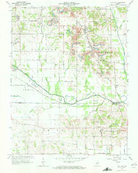
(7)- 1962 Map of Indianapolis
 1962 Indianapolis1962 Print · USGSCentral Indiana and the Illinois borderlands are captured here in the early sixties, showing the region's dense rail networks and growing urban centers. Genealogists and historians can locate family-named landmarks and institutions like Crown Hill Cem, Indiana University, and the Indianapolis Motor Speedway.
 - 1963 Map of Coal City, 1964 Print
 1963 Coal City1964 Print · USGSIndiana's western coal country is revealed in the early 1960s as a landscape of extraction and deep local roots. You can trace the New York Central rail line through Coal City or find family history at Winters Cem and the New Hope Ch.4 unique versions available
 - 1963 Map of Linton, 1964 Print
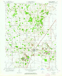
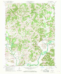
 1963 Linton1964 Print · USGSIndiana's coal country comes into focus in the 1960s, showing the town of Linton as it was intersected by five major rail lines. Genealogists can locate family landmarks like Morris Chapel and the Old Linton Cem, while tracing the growth of the Greene-Sullivan State Forest.4 unique versions available
 - 1963 Map of Switz City, 1964 Print
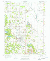
 1963 Switz City1964 Print · USGSRail and coal define this Greene County landscape in the early sixties, centered on the strategic crossing at Switz City. Genealogists and researchers can trace family-named burial sites like Buzan Cem and Tally Cem alongside the industrial footprint of the Illinois Central and local Strip Mines.3 unique versions available
 - 1963 Map of Jasonville, 1965 Print
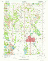
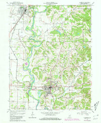
 1963 Jasonville1965 Print · USGSThe coalfields of western Indiana are in full operation during the early sixties, centered on the rail-heavy hub of Jasonville. Researchers can trace the path of the historic Wabash and Erie Canal or locate local landmarks like Friendly Grove Ch and Oak Grove Cem.5 unique versions available
 - 1966 Map of Arney, 1968 Print
 1966 Arney1968 Print · USGSThe confluence of the White and Eel Rivers defines Owen and Greene Counties during the late sixties. Researchers can trace rural life through the Farmers Ferry, the Penn Central rail line, and family landmarks like Griffith Cem and Dutch Bethel Ch.3 unique versions available
 - 1966 Map of Bloomfield, 1981 Print
 1966 Bloomfield1981 Print · USGSGreene County's river-and-rail economy is on full display here in the late sixties, where the winding White River meets industrial and rural life. Genealogists can trace family landmarks and early settlements like Point Commerce, Hashtown, and the Stalcup Cem.2 unique versions available
End of results
Showing maps 1-7 of 7
Top cities of Greene County
- Linton historical maps
- Bloomfield historical maps
- Jasonville historical maps
- Worthington historical maps
- Lyons historical maps
- Switz City historical maps
See more
Frequently asked questions
- What are the different types of historical maps available for Greene County?
- What is the oldest map of Greene County?
- Where can I purchase historical maps of Greene County for my home or office?
- Where can I download high-res historical maps of Greene County?
- Are there historical topographic maps available for Greene County?
- Is there historical aerial imagery available for Greene County?
- Where are historical maps of Greene County sourced from?