1990s Maps of Howard County, Indiana
Explore 2 historic maps of Howard County from the 1990s. These maps offer a rare glimpse into what life looked like during the 1990s — showing old roads, neighborhoods, homes, and landmarks that have changed or disappeared over time.
Whether you're researching your family's past, planning a metal detecting trip, or studying how Howard County's landscape evolved across the 1990s, these high-resolution maps are a powerful tool for exploring the history of this region.
- Focus on a specific era: All maps on this page are from the 1990s, giving you a focused view of this time period.
- See what’s changed: Compare century-old streets, trails, and buildings to today's modern landscape using overlays and satellite layers.
- Research with precision: Use these maps for genealogy, historical research, land use analysis, or educational projects.
- View, download, or print: Maps are fully viewable online in high resolution, and can be downloaded or printed for your own records.
Start exploring Howard County's history through authentic maps from the 1990s. This is your window into the past.
Howard County, IN maps
(2)- 1992 Map of Kokomo West, 1995 Print
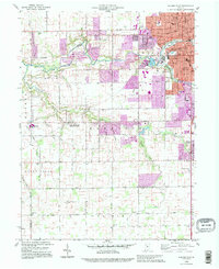 1992 Kokomo West1995 Print · USGSHoward County's western outskirts and the growing city of Kokomo are captured here in the early nineties as suburban expansion met rural farmland. Researchers can trace local community roots through landmarks like West Middleton, Shiloh Ch, and the Western High Sch.
 - 1992 Map of Sweetser, 1995 Print
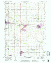 1992 Sweetser1995 Print · USGSThe rural-industrial landscape of Grant and Miami counties is captured in the early nineties. Researchers can trace the Central Railroad of Indianapolis past Swayzee and locate sites like Thrailkill Cem and Sims.
End of results
Showing maps 1-2 of 2
Top cities of Howard County
Frequently asked questions
- What are the different types of historical maps available for Howard County?
- What is the oldest map of Howard County?
- Where can I purchase historical maps of Howard County for my home or office?
- Where can I download high-res historical maps of Howard County?
- Are there historical topographic maps available for Howard County?
- Is there historical aerial imagery available for Howard County?
- Where are historical maps of Howard County sourced from?