1960s Maps of Howard County, Indiana
Explore 11 historic maps of Howard County from the 1960s. These maps offer a rare glimpse into what life looked like during the 1960s — showing old roads, neighborhoods, homes, and landmarks that have changed or disappeared over time.
Whether you're researching your family's past, planning a metal detecting trip, or studying how Howard County's landscape evolved across the 1960s, these high-resolution maps are a powerful tool for exploring the history of this region.
- Focus on a specific era: All maps on this page are from the 1960s, giving you a focused view of this time period.
- See what’s changed: Compare century-old streets, trails, and buildings to today's modern landscape using overlays and satellite layers.
- Research with precision: Use these maps for genealogy, historical research, land use analysis, or educational projects.
- View, download, or print: Maps are fully viewable online in high resolution, and can be downloaded or printed for your own records.
Start exploring Howard County's history through authentic maps from the 1960s. This is your window into the past.
Howard County, IN maps
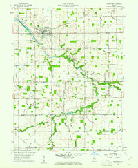
(11)- 1960 Map of Point Isabel, 1961 Print
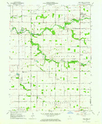
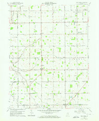 1960 Point Isabel1961 Print · USGSAgricultural life in central Indiana comes into focus during the early sixties, showing a landscape of small crossroads and family-named ditches. Genealogists can locate Antioch Ch, Knox Chapel, and the settlement of Point Isabel.4 unique versions available
 - 1960 Map of Kokomo West, 1961 Print
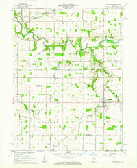
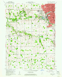 1960 Kokomo West1961 Print · USGSThe western edge of Kokomo was undergoing steady post-war growth when this survey was conducted. Local researchers can trace family roots through landmarks like West Middleton, the Shiloh Church, and the New York Chicago and St Louis Railroad corridor.3 unique versions available
 - 1960 Map of Kokomo East, 1961 Print
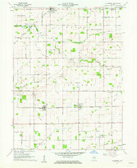
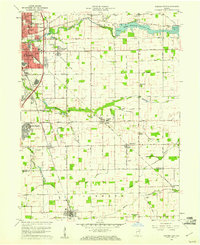 1960 Kokomo East1961 Print · USGSThe Howard County countryside meets the rising industrial sprawl of Kokomo during the early sixties. Genealogists can trace family names and local landmarks through sites like Crown Point Cemetery, Darrough Chapel, and the rural Township Sch.3 unique versions available
 - 1960 Map of Kempton, 1961 Print
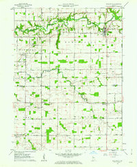
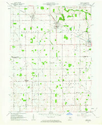
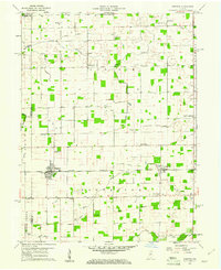 1960 Kempton1961 Print · USGSCentral Indiana's agricultural heartland is documented here in the early sixties, showing the vital rail-and-canal network. Trace family roots at Kempton Cem or explore the rural clusters of Groomsville and Normanda along the New York Chicago and St Louis railroad.2 unique versions available
 - 1960 Map of Greentown, 1961 Print
 1960 Greentown1961 Print · USGSHoward County's agricultural heartland is documented here in the early sixties as the railroad era met a modernizing landscape. Trace the development of Greentown and smaller rural hamlets like Jerome and Phlox, alongside historic sites such as New Salem Ch and the Jerome Cem.4 unique versions available
 - 1961 Map of Russiaville, 1962 Print
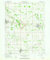
 1961 Russiaville1962 Print · USGSThe crossroads of Russiaville and the winding Wildcat Creek define this Howard County landscape in the early sixties. Genealogists can trace family roots through numerous sites like Old Prophet Cem, Howard Ch, and the settlement of New London.3 unique versions available
 - 1961 Map of Hillisburg, 1962 Print
 1961 Hillisburg1962 Print · USGSClinton and Howard counties show a landscape of rail-connected grain hubs and rural cemeteries in the early 1960s. Genealogists can locate family burial plots at Prairie Chapel Cem and Bacon Cem or trace the early paths of the St Louis and Chicago Road.2 unique versions available
 - 1961 Map of Burlington, 1962 Print
 1961 Burlington1962 Print · USGSCarroll and Clinton counties are captured here in the early sixties, showing a landscape defined by the winding Wildcat Creek and small rural intersections. Researchers can locate numerous historic burial grounds like Old Chaney Cem and Hye Park Cem or the rural Koro Church.3 unique versions available
 - 1962 Map of Deer Creek, 1963 Print
 1962 Deer Creek1963 Print · USGSCarroll County, Indiana, is captured here in the early 1960s as a thriving agricultural landscape defined by its namesake creek and local townships. Genealogists and local historians can locate specific landmarks like Paint Creek Ch, Hopewell Cem, and the community of Wheeling.
 - 1962 Map of Amboy, 1963 Print
 1962 Amboy1963 Print · USGSMiami and Howard counties appear here in the early sixties as a thriving rail-and-farming landscape. Genealogists and local historians can trace family-named sites like Herchberger Cem, visit North Grove Ch, or follow the Pennsylvania Railroad through Amboy.2 unique versions available
 - 1962 Map of Sweetser, 1963 Print
 1962 Sweetser1963 Print · USGSGrant County in the early sixties was a hub of rural industry and local rail transport. Genealogists and historians can trace family roots at Thrailkill Cemetery, explore the rail sidings of Swayzee, or locate the Richland Chapel and Oak Hill High School.
End of results
Showing maps 1-11 of 11
Top cities of Howard County
Frequently asked questions
- What are the different types of historical maps available for Howard County?
- What is the oldest map of Howard County?
- Where can I purchase historical maps of Howard County for my home or office?
- Where can I download high-res historical maps of Howard County?
- Are there historical topographic maps available for Howard County?
- Is there historical aerial imagery available for Howard County?
- Where are historical maps of Howard County sourced from?