1970s Maps of Huntington County, Indiana
Explore 4 historic maps of Huntington County from the 1970s. These maps offer a rare glimpse into what life looked like during the 1970s — showing old roads, neighborhoods, homes, and landmarks that have changed or disappeared over time.
Whether you're researching your family's past, planning a metal detecting trip, or studying how Huntington County's landscape evolved across the 1970s, these high-resolution maps are a powerful tool for exploring the history of this region.
- Focus on a specific era: All maps on this page are from the 1970s, giving you a focused view of this time period.
- See what’s changed: Compare century-old streets, trails, and buildings to today's modern landscape using overlays and satellite layers.
- Research with precision: Use these maps for genealogy, historical research, land use analysis, or educational projects.
- View, download, or print: Maps are fully viewable online in high resolution, and can be downloaded or printed for your own records.
Start exploring Huntington County's history through authentic maps from the 1970s. This is your window into the past.
Huntington County, IN maps
(4)- 1972 Map of Huntington, 1974 Print
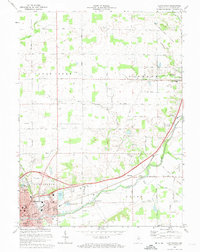 1972 Huntington1974 Print · USGSNortheastern Indiana during the early seventies shows the city of Huntington expanding alongside active rail lines and historical landmarks. Genealogists and historians can trace the Old Indian Treaty Boundary and locate rural sites like Pleasant Chapel and France Cem.3 unique versions available
 - 1972 Map of Bippus, 1974 Print
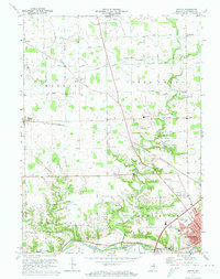 1972 Bippus1974 Print · USGSHuntington County farmland and the northern reaches of the county seat are captured here in the early seventies as the region modernized. Genealogists and local historians can trace family locations near Bippus, St Peters Cem, and the Erie-Lackawanna rail line.
 - 1972 Map of Zanesville, 1974 Print
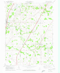 1972 Zanesville1974 Print · USGSThe Indiana countryside near the Huntington, Allen, and Wells county lines is captured here in the early seventies. Trace the Old Indian Treaty Boundary or locate family landmarks like Hoverstock Cem and Temple Timbers Ch.
 - 1973 Map of Markle, 1974 Print
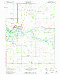 1973 Markle1974 Print · USGSMarkle and the surrounding Huntington County farmland are shown in detail during the early 1970s. Local researchers can trace the OLD INDIAN TREATY BOUNDARY or locate family sites near Horeb Cem, Rockford, and Buckeye Ch.2 unique versions available
End of results
Showing maps 1-4 of 4
Top cities of Huntington County
- Huntington historical maps
- Roanoke historical maps
- Warren historical maps
- Lancaster historical maps
- Andrews historical maps
- Mount Etna historical maps
Frequently asked questions
- What are the different types of historical maps available for Huntington County?
- What is the oldest map of Huntington County?
- Where can I purchase historical maps of Huntington County for my home or office?
- Where can I download high-res historical maps of Huntington County?
- Are there historical topographic maps available for Huntington County?
- Is there historical aerial imagery available for Huntington County?
- Where are historical maps of Huntington County sourced from?