1960s Maps of Huntington, Indiana
Explore 2 historic maps of Huntington from the 1960s. These maps offer a rare glimpse into what life looked like during the 1960s — showing old roads, neighborhoods, homes, and landmarks that have changed or disappeared over time.
Whether you're researching your family's past, planning a metal detecting trip, or studying how Huntington's landscape evolved across the 1960s, these high-resolution maps are a powerful tool for exploring the history of this region.
- Focus on a specific era: All maps on this page are from the 1960s, giving you a focused view of this time period.
- See what’s changed: Compare century-old streets, trails, and buildings to today's modern landscape using overlays and satellite layers.
- Research with precision: Use these maps for genealogy, historical research, land use analysis, or educational projects.
- View, download, or print: Maps are fully viewable online in high resolution, and can be downloaded or printed for your own records.
Start exploring Huntington's history through authentic maps from the 1960s. This is your window into the past.
Huntington, IN maps
(2)- 1969 Map of Majenica, 1971 Print
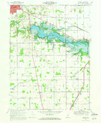 1969 Majenica1971 Print · USGSHuntington County at the end of the sixties reveals a landscape transformed by the new Huntington Reservoir and recreation areas. Researchers can trace rural family roots through the Loon Creek Ch and several local burial sites like Barnes Cem and Yankeetown Cem.3 unique versions available
 - 1969 Map of Andrews, 1971 Print
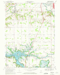 1969 Andrews1971 Print · USGSHuntington County's landscape undergoes a significant shift in the late sixties as the newly formed Salamonie Reservoir alters the local geography. Family historians can trace rural roots through the German Settlement Cem, the town of Andrews, and landmarks like Pilcher Chapel.3 unique versions available
End of results
Showing maps 1-2 of 2
Top cities near Huntington
- Fort Wayne historical maps
- Aboite historical maps
- South Whitley historical maps
- Roanoke historical maps
- Warren historical maps
- Lancaster historical maps
See more
Frequently asked questions
- What are the different types of historical maps available for Huntington?
- What is the oldest map of Huntington?
- Where can I purchase historical maps of Huntington for my home or office?
- Where can I download high-res historical maps of Huntington?
- Are there historical topographic maps available for Huntington?
- Is there historical aerial imagery available for Huntington?
- Where are historical maps of Huntington sourced from?