1960s Maps of Greenwood, Indiana
Explore 4 historic maps of Greenwood from the 1960s. These maps offer a rare glimpse into what life looked like during the 1960s — showing old roads, neighborhoods, homes, and landmarks that have changed or disappeared over time.
Whether you're researching your family's past, planning a metal detecting trip, or studying how Greenwood's landscape evolved across the 1960s, these high-resolution maps are a powerful tool for exploring the history of this region.
- Focus on a specific era: All maps on this page are from the 1960s, giving you a focused view of this time period.
- See what’s changed: Compare century-old streets, trails, and buildings to today's modern landscape using overlays and satellite layers.
- Research with precision: Use these maps for genealogy, historical research, land use analysis, or educational projects.
- View, download, or print: Maps are fully viewable online in high resolution, and can be downloaded or printed for your own records.
Start exploring Greenwood's history through authentic maps from the 1960s. This is your window into the past.
Greenwood, IN maps
(4)- 1962 Map of Indianapolis
 1962 Indianapolis1962 Print · USGSCentral Indiana and the Illinois borderlands are captured here in the early sixties, showing the region's dense rail networks and growing urban centers. Genealogists and historians can locate family-named landmarks and institutions like Crown Hill Cem, Indiana University, and the Indianapolis Motor Speedway.
 - 1962 Map of Bargersville, 1963 Print
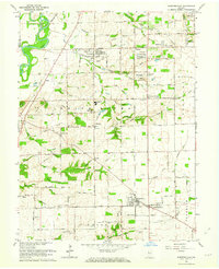 1962 Bargersville1963 Print · USGSJohnson County is shown here in the early sixties as small crossroads settlements like Kinder and Stones Crossing sat amidst a landscape of family farms. Researchers can locate numerous family burial grounds including Boles Cem and McColgin Cem along the Illinois Central Railroad.4 unique versions available
 - 1967 Map of Maywood, 1969 Print
 1967 Maywood1969 Print · USGSMarion County's southern industrial and residential sprawl is captured here in the late sixties as the city pushed toward the Johnson County line. Researchers can trace family roots at Indiana Central College, locate the old Union Stockyards, or find records at Calvary Cemetery.3 unique versions available
 - 1967 Map of Beech Grove, 1969 Print
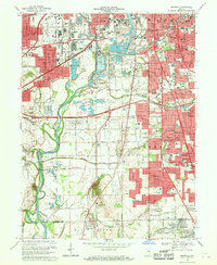
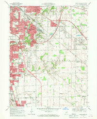 1967 Beech Grove1969 Print · USGSSoutheastern Indianapolis and the industrial hub of Beech Grove are captured here during a period of rapid suburban growth. Genealogists and local historians can trace the development of Southport and New Bethel or locate schools and landmarks like Skyway Airport and the Penn Central rail lines.4 unique versions available
End of results
Showing maps 1-4 of 4
Top cities near Greenwood
- Indianapolis historical maps
- Plainfield historical maps
- Franklin historical maps
- Brownsburg historical maps
- Beech Grove historical maps
- Avon historical maps
See more
Top neighborhoods of Greenwood
- Spring Hill historical maps
- Imperial Hills historical maps
- McCarty historical maps
- Stones Crossing historical maps
- Green Valley historical maps
- Hendricks historical maps
See more
Frequently asked questions
- What are the different types of historical maps available for Greenwood?
- What is the oldest map of Greenwood?
- Where can I purchase historical maps of Greenwood for my home or office?
- Where can I download high-res historical maps of Greenwood?
- Are there historical topographic maps available for Greenwood?
- Is there historical aerial imagery available for Greenwood?
- Where are historical maps of Greenwood sourced from?