1990s Maps of Greenwood, Indiana
Explore 4 historic maps of Greenwood from the 1990s. These maps offer a rare glimpse into what life looked like during the 1990s — showing old roads, neighborhoods, homes, and landmarks that have changed or disappeared over time.
Whether you're researching your family's past, planning a metal detecting trip, or studying how Greenwood's landscape evolved across the 1990s, these high-resolution maps are a powerful tool for exploring the history of this region.
- Focus on a specific era: All maps on this page are from the 1990s, giving you a focused view of this time period.
- See what’s changed: Compare century-old streets, trails, and buildings to today's modern landscape using overlays and satellite layers.
- Research with precision: Use these maps for genealogy, historical research, land use analysis, or educational projects.
- View, download, or print: Maps are fully viewable online in high resolution, and can be downloaded or printed for your own records.
Start exploring Greenwood's history through authentic maps from the 1990s. This is your window into the past.
Greenwood, IN maps
(4)- 1992 Map of Bargersville, 1995 Print
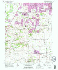 1992 Bargersville1995 Print · USGSJohnson County transitions from its river heritage to modern suburban growth in the early nineties. Genealogists can trace family footprints at Old Bargersville, Honey Creek Cem, and landmarks like Sally Doty Hill.
 - 1992 Map of Greenwood, 1995 Print
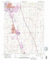 1992 Greenwood1995 Print · USGSJohnson County experiences significant suburban growth in the early nineties as residential developments expand along the rail corridor. Researchers can trace local lineage through Greenwood Cemetery, Hurricane Cem, and historic country congregations like Mount Zion Ch.
 - 1998 Map of Maywood, 2002 Print
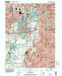 1998 Maywood2002 Print · USGSThe southern suburbs of Indianapolis and the White River valley are captured here in the late 1990s as residential growth meets legacy industry. Researchers can locate family roots at Hebrew Cemetery or trace the early footprint of Indiana Central College and Stout Field.
 - 1998 Map of Beech Grove, 2002 Print
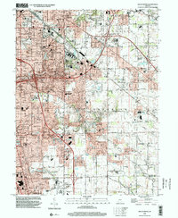 1998 Beech Grove2002 Print · USGSSoutheast of Indianapolis in the late nineties, this area reveals a landscape of maturing suburbs and industrial rail corridors. Genealogists can trace family sites near New Crown Cemetery, Wanamaker, and St Johns Cem & Ch.
End of results
Showing maps 1-4 of 4
Top cities near Greenwood
- Indianapolis historical maps
- Plainfield historical maps
- Franklin historical maps
- Brownsburg historical maps
- Beech Grove historical maps
- Avon historical maps
See more
Top neighborhoods of Greenwood
- Spring Hill historical maps
- Imperial Hills historical maps
- McCarty historical maps
- Stones Crossing historical maps
- Green Valley historical maps
- Hendricks historical maps
See more
Frequently asked questions
- What are the different types of historical maps available for Greenwood?
- What is the oldest map of Greenwood?
- Where can I purchase historical maps of Greenwood for my home or office?
- Where can I download high-res historical maps of Greenwood?
- Are there historical topographic maps available for Greenwood?
- Is there historical aerial imagery available for Greenwood?
- Where are historical maps of Greenwood sourced from?