1960s Maps of Kosciusko County, Indiana
Explore 10 historic maps of Kosciusko County from the 1960s. These maps offer a rare glimpse into what life looked like during the 1960s — showing old roads, neighborhoods, homes, and landmarks that have changed or disappeared over time.
Whether you're researching your family's past, planning a metal detecting trip, or studying how Kosciusko County's landscape evolved across the 1960s, these high-resolution maps are a powerful tool for exploring the history of this region.
- Focus on a specific era: All maps on this page are from the 1960s, giving you a focused view of this time period.
- See what’s changed: Compare century-old streets, trails, and buildings to today's modern landscape using overlays and satellite layers.
- Research with precision: Use these maps for genealogy, historical research, land use analysis, or educational projects.
- View, download, or print: Maps are fully viewable online in high resolution, and can be downloaded or printed for your own records.
Start exploring Kosciusko County's history through authentic maps from the 1960s. This is your window into the past.
Kosciusko County, IN maps
(10)- 1961 Map of Silver Lake, 1963 Print
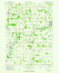
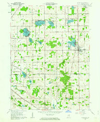 1961 Silver Lake1963 Print · USGSThe lake country of Kosciusko County comes into focus in the early sixties, showing the intersection of rural agriculture and rail-side industry. Genealogists can trace family roots through sites like Graceland Cem, Silver Creek Ch, and the small settlement of Disko.2 unique versions available
 - 1961 Map of Lake Wawasee, 1963 Print
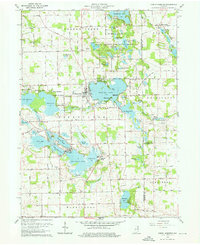
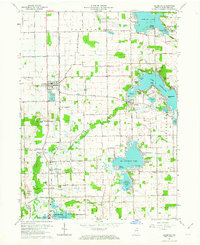
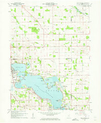 1961 Lake Wawasee1963 Print · USGSKosciusko County lakelife in the early sixties centers on Lake Wawasee and its surrounding communities. Researchers can trace family history through sites like Hire Cemetery, Juday School, and the lakeside settlements of Vawter Park and Pickwick Park.3 unique versions available
 - 1961 Map of Burket, 1963 Print
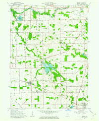 1961 Burket1963 Print · USGSKosciusko County’s agricultural and rail landscape is captured here in the early sixties as the Tippecanoe River winds through the northern townships. Researchers can trace the footprints of Palestine and Burket, locating family landmarks like Cooks Chapel, Township Sch, and Nye Cem.3 unique versions available
 - 1962 Map of North Manchester North, 1963 Print
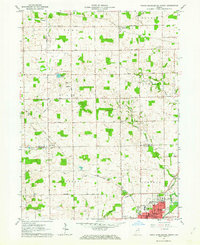 1962 North Manchester North1963 Print · USGSKosciusko and Wabash counties are captured here in the early sixties, showing the rural grid and rail towns of northern Indiana. Genealogists can trace family sites at Rose Hill Cem, West Eel River Ch, and the grounds of Manchester College.2 unique versions available
 - 1962 Map of South Whitley West, 1963 Print
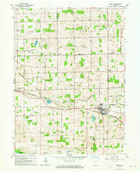
 1962 South Whitley West1963 Print · USGSIndiana's Eel River valley comes into sharp focus during the early sixties as a thriving corridor of rail and river commerce. Genealogists and historians can trace the foundations of South Whitley, explore the grounds of Township Sch, or locate family plots in Glenwood Cem and Union Cem.2 unique versions available
 - 1962 Map of Milford, 1963 Print
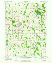
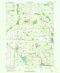 1962 Milford1963 Print · USGSNorthern Indiana's rail and river networks are in full view during the early sixties, centered on the crossing of major lines. Genealogists and local historians can trace the locations of Milford Cem, Bethany Sch, and family sites near Wabee Lake.3 unique versions available
 - 1962 Map of Akron, 1964 Print
 1962 Akron1964 Print · USGSAkron and the Fulton-Kosciusko county line are shown here in the early sixties, a period when rail service still anchored these agricultural townships. Researchers can locate family landmarks such as Bethlehem Ch, Mt Hope Athens Cem, and the small settlement of Athens.3 unique versions available
 - 1962 Map of North Webster, 1964 Print
 1962 North Webster1964 Print · USGSKosciusko County lakeland in the early sixties reveals a landscape of summer camps and sprawling shoreline settlements. Trace family roots and local history at Indian Village, Mock Cem, and the specialized Tri-County State Fish and Game Area.4 unique versions available
 - 1962 Map of Leesburg, 1964 Print
 1962 Leesburg1964 Print · USGSKosciusko County lake country in the early sixties shows a landscape of lakeside retreats and traditional Indiana farmland. Researchers can trace the Old Indian Treaty Boundary and locate family landmarks like New Salem Church or Groves Cemetery.2 unique versions available
 - 1962 Map of Pierceton, 1964 Print
 1962 Pierceton1964 Print · USGSNortheastern Indiana during the early 1960s shows a landscape of glacial lakes and small-town rail hubs. Trace the paths of the Pennsylvania Railroad and Lincoln Highway past Hillcrest Cem and Sellers Lake.2 unique versions available
End of results
Showing maps 1-10 of 10
Top cities of Kosciusko County
- Warsaw historical maps
- Winona Lake historical maps
- Syracuse historical maps
- Milford historical maps
- North Webster historical maps
- Silver Lake historical maps
See more
Frequently asked questions
- What are the different types of historical maps available for Kosciusko County?
- What is the oldest map of Kosciusko County?
- Where can I purchase historical maps of Kosciusko County for my home or office?
- Where can I download high-res historical maps of Kosciusko County?
- Are there historical topographic maps available for Kosciusko County?
- Is there historical aerial imagery available for Kosciusko County?
- Where are historical maps of Kosciusko County sourced from?