1900s (20th Century) Maps of Warsaw, Indiana
Explore 10 historic maps of Warsaw from the 1900s (20th Century). These maps offer a rare glimpse into what life looked like during the 1900s — showing old roads, neighborhoods, homes, and landmarks that have changed or disappeared over time.
Whether you're researching your family's past, planning a metal detecting trip, or studying how Warsaw's landscape evolved across the 1900s, these high-resolution maps are a powerful tool for exploring the history of this region.
- Focus on a specific era: All maps on this page are from the 1900s, giving you a focused view of this time period.
- See what’s changed: Compare century-old streets, trails, and buildings to today's modern landscape using overlays and satellite layers.
- Research with precision: Use these maps for genealogy, historical research, land use analysis, or educational projects.
- View, download, or print: Maps are fully viewable online in high resolution, and can be downloaded or printed for your own records.
Start exploring Warsaw's history through authentic maps from the 1900s. This is your window into the past.
Warsaw, IN maps
(10)- 1950 Map of Leesburg, 1952 Print
 1950 Leesburg1952 Print · USGSKosciusko County at the start of the fifties shows a lakefront landscape evolving through rail and air travel. Trace family roots at New Salem or Dutchtown, and explore the shoreline landings at Big Chapman Lake and the grounds of the Tippecanoe Country Club.2 unique versions available
 - 1953 Map of Fort Wayne, 1963 Print
 1953 Fort Wayne1963 Print · USGSNortheast Indiana and its neighboring borderlands in Michigan and Ohio appear here during a peak era of rail and road expansion. Researchers can trace the massive rail networks of the Nickel Plate Road and Wabash or locate lakeside landmarks like Lake Wawasee and Clear Lake.4 unique versions available
 - 1956 Map of Fort Wayne
 1956 Fort Wayne1956 Print · USGSThe tri-state borderlands of Indiana, Michigan, and Ohio are captured here in the mid-fifties, centered on the growing industrial hub of Fort Wayne. Researchers can trace the heavy rail lines of the New York Central and Pennsylvania alongside prominent water features like Lake Wawasee and the Maumee River.2 unique versions available
 - 1957 Map of Warsaw, 1959 Print
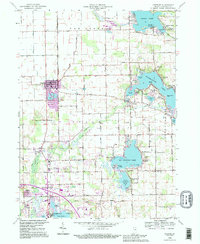
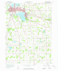 1957 Warsaw1959 Print · USGSKosciusko County centers on the growing hub of Warsaw and the lakefront campus of Winona Lake during the late 1950s. Genealogists can trace family landmarks like Oakwood Cemetery, the County Home, and local schools including Consolidated Sch.4 unique versions available
 - 1959 Map of Atwood, 1960 Print
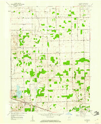 1959 Atwood1960 Print · USGSKosciusko County in the late fifties reveals a landscape of productive farmland and small rail-oriented towns. Researchers can trace family history through sites like Graber Cem and Highland Cem or locate vintage landmarks like the Drive-in Theater near Atwood.3 unique versions available
 - 1961 Map of Burket, 1963 Print
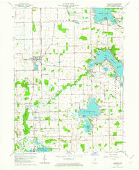
 1961 Burket1963 Print · USGSKosciusko County’s agricultural and rail landscape is captured here in the early sixties as the Tippecanoe River winds through the northern townships. Researchers can trace the footprints of Palestine and Burket, locating family landmarks like Cooks Chapel, Township Sch, and Nye Cem.3 unique versions available
 - 1962 Map of Leesburg, 1964 Print
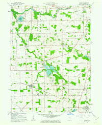
 1962 Leesburg1964 Print · USGSKosciusko County lake country in the early sixties shows a landscape of lakeside retreats and traditional Indiana farmland. Researchers can trace the Old Indian Treaty Boundary and locate family landmarks like New Salem Church or Groves Cemetery.2 unique versions available
 - 1984 Map of Fort Wayne, 1985 Print
 1984 Fort Wayne1985 Print · USGSNortheast Indiana in the mid-1980s reveals a complex landscape of glacial lakes, thriving college towns, and heavy rail infrastructure. Researchers can trace the development of Winona Lake, locate Manchester College in North Manchester, and find rural landmarks like Oakwood Cem or the Tri-County State Fish and Game Area.
 - 1992 Map of Leesburg, 1995 Print
 1992 Leesburg1995 Print · USGSKosciusko County in the early 1990s reveals a dense network of lakeside communities and historic boundaries. Genealogists can trace family roots through Groves Cem, Dutchtown Ch, and the old Old Indian Treaty Boundary.
 - 1994 Map of Fort Wayne
 1994 Fort Wayne1994 Print · USGSNortheast Indiana in the mid-nineties shows a landscape deeply tied to its glacial lakes and early rail networks. Genealogists and historians can trace old transit lines like the Old Ind RR and explore lakeside settlements such as Enchanted Hills and Syracuse.
End of results
Showing maps 1-10 of 10
Top cities near Warsaw
- Nappanee historical maps
- North Manchester historical maps
- Locke historical maps
- Winona Lake historical maps
- Syracuse historical maps
- South Whitley historical maps
See more
Top neighborhoods of Warsaw
Frequently asked questions
- What are the different types of historical maps available for Warsaw?
- What is the oldest map of Warsaw?
- Where can I purchase historical maps of Warsaw for my home or office?
- Where can I download high-res historical maps of Warsaw?
- Are there historical topographic maps available for Warsaw?
- Is there historical aerial imagery available for Warsaw?
- Where are historical maps of Warsaw sourced from?