1990s Maps of Cedar Creek Township, Indiana
Explore 5 historic maps of Cedar Creek Township from the 1990s. These maps offer a rare glimpse into what life looked like during the 1990s — showing old roads, neighborhoods, homes, and landmarks that have changed or disappeared over time.
Whether you're researching your family's past, planning a metal detecting trip, or studying how Cedar Creek Township's landscape evolved across the 1990s, these high-resolution maps are a powerful tool for exploring the history of this region.
- Focus on a specific era: All maps on this page are from the 1990s, giving you a focused view of this time period.
- See what’s changed: Compare century-old streets, trails, and buildings to today's modern landscape using overlays and satellite layers.
- Research with precision: Use these maps for genealogy, historical research, land use analysis, or educational projects.
- View, download, or print: Maps are fully viewable online in high resolution, and can be downloaded or printed for your own records.
Start exploring Cedar Creek Township's history through authentic maps from the 1990s. This is your window into the past.
Cedar Creek Township, IN maps
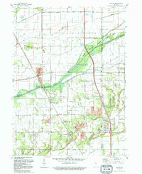
(5)- 1991 Map of Kankakee
 1991 Kankakee1991 Print · USGSThe Illinois-Indiana borderlands come into focus during the early nineties, centered on the growing Kankakee valley and its sprawling drainage systems. Trace the rail-and-river economy through landmarks like the Wilton Railroad Grade, the Manteno State Hospital, and the historic Old Pioneer Cem.
 - 1992 Map of Shelby
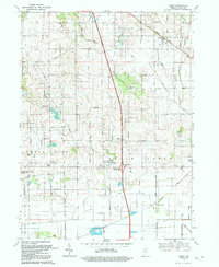
 1992 Shelby1992 Print · USGSNorthwestern Indiana's river-and-rail corridor is captured here in the early nineties, showing the managed wetlands of the Kankakee valley. Genealogists and local historians can trace the foundations of Shelby, Roselawn, and the Monon RR line that once drove the local economy.
 - 1992 Map of Lowell
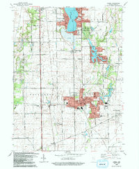 1992 Lowell1992 Print · USGSSouthern Lake County is captured here in the early nineties, showing a landscape of growing lakeside communities and deep-rooted farmsteads. Genealogists can trace family landmarks and local institutions, including St Edwards Cem, the settlement of North Hayden, and the sprawling Buckley Homestead County Park.
 - 1992 Map of Leroy
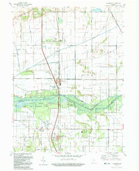
 1992 Leroy1992 Print · USGSLake County agriculture and small-town settlements are captured here in the early nineties, revealing a landscape of managed waterways and historic groves. Genealogists can locate family sites at Plum Grove Cem, the old village of Leroy, and Rangeline Ch.
 - 1992 Map of Schneider
 1992 Schneider1992 Print · USGSThe Kankakee River valley in northwest Indiana was a landscape of reclaimed marshlands and riverfront retreats by the early 1990s. Trace the rural layout of Schneider and Lake Village, and find family history at Sanders Cem or St Augusta Ch.
End of results
Showing maps 1-5 of 5
Top cities near Cedar Creek Township
- Merrillville historical maps
- Schererville historical maps
- Hobart historical maps
- Crown Point historical maps
- Cedar Lake historical maps
- Sauk Village historical maps
See more
Top neighborhoods of Cedar Creek Township
- Orchard Grove historical maps
- Lake Dalecarlia historical maps
- Shelby historical maps
- Lowell historical maps
- Cedar Creek Heights historical maps
Frequently asked questions
- What are the different types of historical maps available for Cedar Creek Township?
- What is the oldest map of Cedar Creek Township?
- Where can I purchase historical maps of Cedar Creek Township for my home or office?
- Where can I download high-res historical maps of Cedar Creek Township?
- Are there historical topographic maps available for Cedar Creek Township?
- Is there historical aerial imagery available for Cedar Creek Township?
- Where are historical maps of Cedar Creek Township sourced from?