1960s Maps of West Creek Township, Indiana
Explore 2 historic maps of West Creek Township from the 1960s. These maps offer a rare glimpse into what life looked like during the 1960s — showing old roads, neighborhoods, homes, and landmarks that have changed or disappeared over time.
Whether you're researching your family's past, planning a metal detecting trip, or studying how West Creek Township's landscape evolved across the 1960s, these high-resolution maps are a powerful tool for exploring the history of this region.
- Focus on a specific era: All maps on this page are from the 1960s, giving you a focused view of this time period.
- See what’s changed: Compare century-old streets, trails, and buildings to today's modern landscape using overlays and satellite layers.
- Research with precision: Use these maps for genealogy, historical research, land use analysis, or educational projects.
- View, download, or print: Maps are fully viewable online in high resolution, and can be downloaded or printed for your own records.
Start exploring West Creek Township's history through authentic maps from the 1960s. This is your window into the past.
West Creek Township, IN maps
(2)- 1962 Map of Lowell, 1964 Print
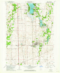 1962 Lowell1964 Print · USGSLake County at the start of the sixties reveals a landscape shaped by agricultural townships and growing lakeside communities. Genealogists and historians can trace family roots at St Edwards School, German Cemetery, and across the transit corridor of the Monon Railroad.2 unique versions available
 - 1963 Map of Illiana Heights, 1965 Print
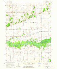 1963 Illiana Heights1965 Print · USGSThe Illinois-Indiana state line comes alive in the early sixties as riverfront life and rail junctions define the Kankakee valley. Genealogists and historians can trace riverside settlements like Garden of Eden, search for family roots at West Creek Cem, or follow the path of the NEW YORK CENTRAL railroad.3 unique versions available
End of results
Showing maps 1-2 of 2
Top cities near West Creek Township
- Merrillville historical maps
- Schererville historical maps
- Hobart historical maps
- Chicago Heights historical maps
- Crown Point historical maps
- Park Forest historical maps
See more
Top neighborhoods of West Creek Township
- Illinoi historical maps
- Lowell historical maps
- North Hayden historical maps
- Creston historical maps
- Schneider historical maps
Frequently asked questions
- What are the different types of historical maps available for West Creek Township?
- What is the oldest map of West Creek Township?
- Where can I purchase historical maps of West Creek Township for my home or office?
- Where can I download high-res historical maps of West Creek Township?
- Are there historical topographic maps available for West Creek Township?
- Is there historical aerial imagery available for West Creek Township?
- Where are historical maps of West Creek Township sourced from?