1960s Maps of Winfield Township, Indiana
Explore 4 historic maps of Winfield Township from the 1960s. These maps offer a rare glimpse into what life looked like during the 1960s — showing old roads, neighborhoods, homes, and landmarks that have changed or disappeared over time.
Whether you're researching your family's past, planning a metal detecting trip, or studying how Winfield Township's landscape evolved across the 1960s, these high-resolution maps are a powerful tool for exploring the history of this region.
- Focus on a specific era: All maps on this page are from the 1960s, giving you a focused view of this time period.
- See what’s changed: Compare century-old streets, trails, and buildings to today's modern landscape using overlays and satellite layers.
- Research with precision: Use these maps for genealogy, historical research, land use analysis, or educational projects.
- View, download, or print: Maps are fully viewable online in high resolution, and can be downloaded or printed for your own records.
Start exploring Winfield Township's history through authentic maps from the 1960s. This is your window into the past.
Winfield Township, IN maps
(4)- 1962 Map of Palmer, 1964 Print
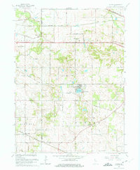 1962 Palmer1964 Print · USGSPorter and Lake Counties are captured here in the early 1960s, showing a landscape of rural crossroads and dense rail networks. Researchers can trace family history through numerous landmarks like Blachly Cem, Salem Ch, and the community at Lake Eliza.3 unique versions available
 - 1962 Map of Crown Point, 1964 Print
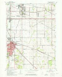 1962 Crown Point1964 Print · USGSLake County enters a period of post-war growth as suburban subdivisions begin to fill the spaces between established rail lines and historic roads. Genealogists and local historians can trace the foundations of Merrillville, locate the Maplewood Cemetery, and find early landmarks like the Crown Point Airfield.4 unique versions available
 - 1969 Map of Hebron, 1971 Print
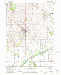 1969 Hebron1971 Print · USGSPorter County is shown during a period of agricultural expansion in the late sixties, as drainage projects reshaped the land. Genealogists can trace family footprints at Hebron Cem or follow the historic rail corridors of the Penn Central and Erie-Lackawanna.2 unique versions available
 - 1969 Map of Leroy, 1971 Print
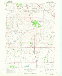 1969 Leroy1971 Print · USGSSouthern Lake County in the late sixties shows a landscape defined by rail lines and drainage canals. Trace rural ancestry at Plum Grove Cem or locate the old Center Sch and the community of Orchard Grove.2 unique versions available
End of results
Showing maps 1-4 of 4
Top cities near Winfield Township
- Hammond historical maps
- Gary historical maps
- Portage historical maps
- Valparaiso historical maps
- Merrillville historical maps
- Schererville historical maps
See more
Top neighborhoods of Winfield Township
- Palmer historical maps
- Leroy historical maps
- Lakes of the Four Seasons historical maps
- Winfield historical maps
- Stony Run Estates historical maps
- The Pointe historical maps
Frequently asked questions
- What are the different types of historical maps available for Winfield Township?
- What is the oldest map of Winfield Township?
- Where can I purchase historical maps of Winfield Township for my home or office?
- Where can I download high-res historical maps of Winfield Township?
- Are there historical topographic maps available for Winfield Township?
- Is there historical aerial imagery available for Winfield Township?
- Where are historical maps of Winfield Township sourced from?