1950s Maps of Madison County, Indiana
Explore 8 historic maps of Madison County from the 1950s. These maps offer a rare glimpse into what life looked like during the 1950s — showing old roads, neighborhoods, homes, and landmarks that have changed or disappeared over time.
Whether you're researching your family's past, planning a metal detecting trip, or studying how Madison County's landscape evolved across the 1950s, these high-resolution maps are a powerful tool for exploring the history of this region.
- Focus on a specific era: All maps on this page are from the 1950s, giving you a focused view of this time period.
- See what’s changed: Compare century-old streets, trails, and buildings to today's modern landscape using overlays and satellite layers.
- Research with precision: Use these maps for genealogy, historical research, land use analysis, or educational projects.
- View, download, or print: Maps are fully viewable online in high resolution, and can be downloaded or printed for your own records.
Start exploring Madison County's history through authentic maps from the 1950s. This is your window into the past.
Madison County, IN maps
(8)- 1952 Map of Ingalls, 1953 Print
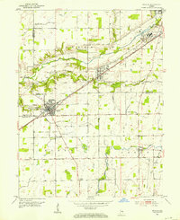 1952 Ingalls1953 Print · USGSCentral Indiana's agricultural and industrial corridor is captured here in the early fifties, following the New York Central line. Genealogists can trace family footprints across dozens of sites like Gravel Lawn Cem, Beech Grove Ch, and the outlying settlement of Eden.
 - 1952 Map of Anderson, 1954 Print
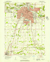 1952 Anderson1954 Print · USGSAnderson and the southern reaches of Madison County are captured in the early fifties during a period of significant postwar growth. Researchers can trace historic family plots at Harmeson Cem, locate the old Sun Valley Speedway, and explore the rail networks of the NY C RR and Pennsylvania RR.
 - 1953 Map of Pendleton, 1954 Print
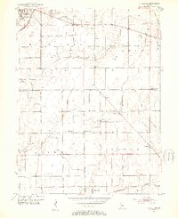 1953 Pendleton1954 Print · USGSThe rural borderlands of Madison and Hancock Counties are meticulously documented here in the early fifties. Researchers can trace family history through numerous rural landmarks like Bunker Cem, Sugar Grove Ch, and the small community at Warrington.2 unique versions available
 - 1953 Map of Lapel, 1954 Print
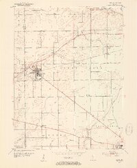 1953 Lapel1954 Print · USGSMadison County in the early fifties shows a landscape of growing towns and established family homesteads. Genealogists and historians can locate markers like Old Woodward Cem, the Limestone Quarry in Lapel, and the rural Old German Ch.2 unique versions available
 - 1953 Map of Cincinnati, 1965 Print
 1953 Cincinnati1965 Print · USGSThe Ohio River valley and the industrial heartland of Indiana and Ohio are captured here during the mid-century peak of rail and river commerce. Genealogists and historians can trace connections between Cincinnati and outlying military sites like Camp Atterbury and Bakalar AFB.3 unique versions available
 - 1953 Map of Muncie, 1966 Print
 1953 Muncie1966 Print · USGSIndiana and Ohio borderlands thrive in the early fifties, showing a landscape defined by manufacturing cities and an intensive railroad network. Genealogists can trace family roots across the Indiana-Ohio line through Muncie, Celina, and Portland via the Pennsylvania railroad.5 unique versions available
 - 1956 Map of Muncie
 1956 Muncie1956 Print · USGSEastern Indiana and western Ohio are shown at a peak of rail-driven industry in the mid-fifties. Genealogists and rail historians can trace the paths of the Pennsylvania RR through Muncie or locate landmarks like Lake Saint Marys (Grand Lake Reservoir) and Frances Slocum State Forest.
 - 1957 Map of Cincinnati
 1957 Cincinnati1957 Print · USGSThe Ohio River valley and its surrounding highlands thrived during the mid-fifties industrial peak, centered on the bustling Cincinnati and Dayton metropolitan hubs. Researchers can trace the extensive rail networks and military sites like Wright-Patterson AFB and Camp Atterbury.
End of results
Showing maps 1-8 of 8
Top cities of Madison County
- Anderson historical maps
- Elwood historical maps
- Alexandria historical maps
- Pendleton historical maps
- Chesterfield historical maps
- Edgewood historical maps
See more
Frequently asked questions
- What are the different types of historical maps available for Madison County?
- What is the oldest map of Madison County?
- Where can I purchase historical maps of Madison County for my home or office?
- Where can I download high-res historical maps of Madison County?
- Are there historical topographic maps available for Madison County?
- Is there historical aerial imagery available for Madison County?
- Where are historical maps of Madison County sourced from?