1960s Maps of Markleville, Indiana
Explore 2 historic maps of Markleville from the 1960s. These maps offer a rare glimpse into what life looked like during the 1960s — showing old roads, neighborhoods, homes, and landmarks that have changed or disappeared over time.
Whether you're researching your family's past, planning a metal detecting trip, or studying how Markleville's landscape evolved across the 1960s, these high-resolution maps are a powerful tool for exploring the history of this region.
- Focus on a specific era: All maps on this page are from the 1960s, giving you a focused view of this time period.
- See what’s changed: Compare century-old streets, trails, and buildings to today's modern landscape using overlays and satellite layers.
- Research with precision: Use these maps for genealogy, historical research, land use analysis, or educational projects.
- View, download, or print: Maps are fully viewable online in high resolution, and can be downloaded or printed for your own records.
Start exploring Markleville's history through authentic maps from the 1960s. This is your window into the past.
Markleville, IN maps
(2)- 1960 Map of Shirley, 1961 Print
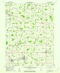 1960 Shirley1961 Print · USGSEast-central Indiana farmland is captured here in the early sixties, centered on the tri-county junction where Shirley meets the NEW YORK CENTRAL line. Local historians can trace family-named landmarks and rural hubs like McCray Cem, Harlan Ch, and the Township High Sch.2 unique versions available
 - 1966 Map of Pendleton, 1968 Print
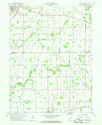 1966 Pendleton1968 Print · USGSMadison and Hancock Counties are captured here in the mid-1960s, showing a landscape of small crossroads settlements and family farms. Trace local history through landmarks like Milners Corner, the Zion Chapel, and old family plots like Cook Cem.
End of results
Showing maps 1-2 of 2
Top cities near Markleville
- Muncie historical maps
- Anderson historical maps
- New Castle historical maps
- Greenfield historical maps
- Yorktown historical maps
- Pendleton historical maps
See more
Frequently asked questions
- What are the different types of historical maps available for Markleville?
- What is the oldest map of Markleville?
- Where can I purchase historical maps of Markleville for my home or office?
- Where can I download high-res historical maps of Markleville?
- Are there historical topographic maps available for Markleville?
- Is there historical aerial imagery available for Markleville?
- Where are historical maps of Markleville sourced from?