1970s Maps of Marshall County, Indiana
Explore 4 historic maps of Marshall County from the 1970s. These maps offer a rare glimpse into what life looked like during the 1970s — showing old roads, neighborhoods, homes, and landmarks that have changed or disappeared over time.
Whether you're researching your family's past, planning a metal detecting trip, or studying how Marshall County's landscape evolved across the 1970s, these high-resolution maps are a powerful tool for exploring the history of this region.
- Focus on a specific era: All maps on this page are from the 1970s, giving you a focused view of this time period.
- See what’s changed: Compare century-old streets, trails, and buildings to today's modern landscape using overlays and satellite layers.
- Research with precision: Use these maps for genealogy, historical research, land use analysis, or educational projects.
- View, download, or print: Maps are fully viewable online in high resolution, and can be downloaded or printed for your own records.
Start exploring Marshall County's history through authentic maps from the 1970s. This is your window into the past.
Marshall County, IN maps
(4)- 1972 Map of Donaldson, 1974 Print
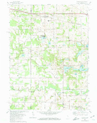 1972 Donaldson1974 Print · USGSThe rural borderlands of Marshall County are captured here in the early 1970s, showing a landscape shaped by rail lines and religious institutions. You can trace the Penn Central tracks through Donaldson or locate local landmarks like Ancilla Domini College and Burr Oak Cem.
 - 1972 Map of La Paz, 1974 Print
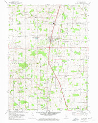 1972 La Paz1974 Print · USGSMarshall County settlement and transit are captured here in the early seventies, centered on the rail hub of La Paz. Researchers can trace family roots through numerous local landmarks like Pine Creek Ch, Mt Zion Cem Ch, and the remote Linkville community.2 unique versions available
 - 1972 Map of Plymouth, 1974 Print
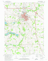 1972 Plymouth1974 Print · USGSMid-century Marshall County thrives as a transit and recreational hub during the early seventies. Genealogists and local historians can trace the foundations of Plymouth through sites like St Michaels Cem, Washington Sch, and the lakeshore developments near Twin Lakes.2 unique versions available
 - 1972 Map of Walkerton, 1974 Print
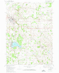 1972 Walkerton1974 Print · USGSIn the early 1970s, the area around Walkerton was a busy rail crossroads for three major lines. Researchers can trace the path of the Baltimore and Ohio railroad through Teegarden or locate family sites near Glenn High Sch and Koontz Lake.
End of results
Showing maps 1-4 of 4
Top cities of Marshall County
- Plymouth historical maps
- Bremen historical maps
- Walnut historical maps
- Bourbon historical maps
- Argos historical maps
- Culver historical maps
See more
Frequently asked questions
- What are the different types of historical maps available for Marshall County?
- What is the oldest map of Marshall County?
- Where can I purchase historical maps of Marshall County for my home or office?
- Where can I download high-res historical maps of Marshall County?
- Are there historical topographic maps available for Marshall County?
- Is there historical aerial imagery available for Marshall County?
- Where are historical maps of Marshall County sourced from?