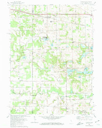
1972 Map of Donaldson
USGS Topo · Published 1974About this map
The Yellow River meanders across this rural landscape at the border of Starke and Marshall Counties, anchoring a region defined by its religious institutions and small crossroads settlements. Academic and spiritual life are prominent at Ancilla Domini College and the Divine Heart Seminary, located near the northern hamlet of Donaldson. The map documents a complex drainage system essential for the surrounding agriculture, including the Blad Ditch and Morse Ditch, which channel water through the township's low-lying areas.
Find a feature on this map
40 named features on this map. Tap any name to fly to it.
Don’t see what you’re looking for? This feature index may not catch every label — zoom into the map to look around manually.
Map Details
Editions of this 1972 Donaldson Map
This is the sole edition of this map. No revisions or reprints were ever made.
Other maps of this area

1953 · Chicago
USGS Topo · 1:250,000

1957 · Chicago
USGS Topo · 1:250,000

1957 · Knox East
USGS Topo · 1:24,000

1957 · Plymouth
USGS Topo · 1:24,000

1958 · Donaldson
USGS Topo · 1:24,000

1958 · La Paz
USGS Topo · 1:24,000

1958 · Hamlet
USGS Topo · 1:24,000

1958 · Walkerton
USGS Topo · 1:24,000

1962 · Bass Lake
USGS Topo · 1:24,000

1962 · Culver
USGS Topo · 1:24,000