1960s Maps of Newton County, Indiana
Explore 13 historic maps of Newton County from the 1960s. These maps offer a rare glimpse into what life looked like during the 1960s — showing old roads, neighborhoods, homes, and landmarks that have changed or disappeared over time.
Whether you're researching your family's past, planning a metal detecting trip, or studying how Newton County's landscape evolved across the 1960s, these high-resolution maps are a powerful tool for exploring the history of this region.
- Focus on a specific era: All maps on this page are from the 1960s, giving you a focused view of this time period.
- See what’s changed: Compare century-old streets, trails, and buildings to today's modern landscape using overlays and satellite layers.
- Research with precision: Use these maps for genealogy, historical research, land use analysis, or educational projects.
- View, download, or print: Maps are fully viewable online in high resolution, and can be downloaded or printed for your own records.
Start exploring Newton County's history through authentic maps from the 1960s. This is your window into the past.
Newton County, IN maps
(13)- 1961 Map of Kentland, 1963 Print
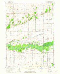
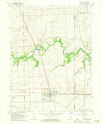
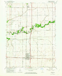 1961 Kentland1963 Print · USGSThe rail intersection at Kentland and the winding Iroquois River define this corner of Newton County during the early sixties. Researchers can find many family landmarks and small community sites like Mt Zion Ch, Dorn Cem, and the County Fairgrounds.2 unique versions available
 - 1961 Map of Mount Ayr, 1964 Print
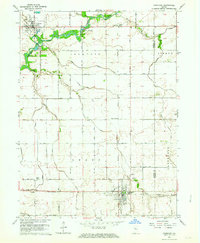
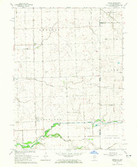
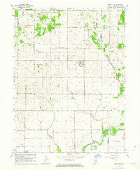 1961 Mount Ayr1964 Print · USGSNewton County's agricultural heartland in the early sixties is centered on Mount Ayr and its surrounding drainage networks. Genealogists and historians can locate rural burial grounds like North Star Cem or trace the legacy of the Old Railroad Grade.2 unique versions available
 - 1961 Map of Morocco, 1964 Print
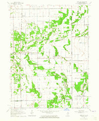
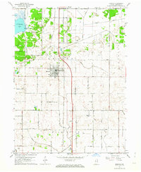 1961 Morocco1964 Print · USGSNewton County in the early sixties centers on the growth of Morocco and the surrounding farmland. Genealogists can trace family roots at Oakland Cem and Beaver City Cem or locate former homesteads near Beaver Creek.
 - 1962 Map of Wadena, 1963 Print
 1962 Wadena1963 Print · USGSBenton County agriculture and rail transit are captured here in the early sixties as the landscape supported a thriving grain-shipping economy. Researchers can locate the Township Sch in Wadena, the Dehner Cem, and traces of an Old Railroad Grade.2 unique versions available
 - 1962 Map of Goodland, 1964 Print
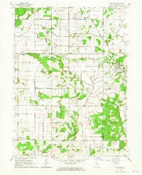
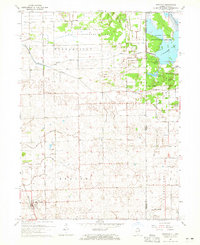
 1962 Goodland1964 Print · USGSNewton County's agricultural heartland is documented here in the early 1960s, showing the intersection of rail and river life. Researchers can trace family roots at Mt Calvary Cem, find the vanished stop at Percy Junction, or locate the historic layout of Goodland.2 unique versions available
 - 1962 Map of Fair Oaks, 1964 Print
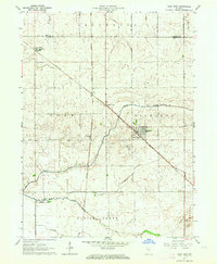
 1962 Fair Oaks1964 Print · USGSNewton and Jasper counties are captured here in the early sixties as a highly engineered agricultural landscape. Genealogists and local historians can trace family lands near Fair Oaks, locate the Township Sch, and follow the path of the Monon Railroad.2 unique versions available
 - 1962 Map of Earl Park, 1964 Print
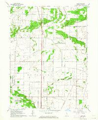
 1962 Earl Park1964 Print · USGSBenton County agriculture and rail transport intersect in the early sixties, centered on the hub of Earl Park. Researchers can trace old family sites and rural infrastructure at Raub, Yeagers Curve, and the St John Cem.2 unique versions available
 - 1962 Map of Enos, 1964 Print
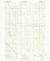
 1962 Enos1964 Print · USGSNewton County's agricultural and conservation landscape is revealed in the early sixties as a network of rail and drainage. Researchers can trace the New York Central Railroad through Enos or locate the Beaver Lake Prairie Chicken Refuge.3 unique versions available
 - 1963 Map of Illiana Heights, 1965 Print
 1963 Illiana Heights1965 Print · USGSThe Illinois-Indiana state line comes alive in the early sixties as riverfront life and rail junctions define the Kankakee valley. Genealogists and historians can trace riverside settlements like Garden of Eden, search for family roots at West Creek Cem, or follow the path of the NEW YORK CENTRAL railroad.3 unique versions available
 - 1963 Map of Leesville, 1965 Print
 1963 Leesville1965 Print · USGSThe Illinois-Indiana borderland is captured here in the early 1960s, showing a landscape of drainage ditches and remote rural settlements. Genealogists and historians can locate Morgan Cem, the Pembroke Sch, and small community centers like Hopkins Park and Leesville.3 unique versions available
 - 1964 Map of Darrow, 1965 Print
 1964 Darrow1965 Print · USGSThe Illinois-Indiana borderlands are captured here in the mid-1960s, showing the quiet rail-and-river geography of Iroquois County. Researchers can trace the Milwaukee Road through Darrow or locate the Blue Ridge Cem near the state line.2 unique versions available
 - 1964 Map of Donovan, 1965 Print
 1964 Donovan1965 Print · USGSDonovan and the eastern edge of Iroquois County appear in the mid-1960s as a productive agricultural landscape bisected by two major railroads. Genealogists and local historians can trace family locations near Beaver Ch, Beaver Cem, and the rail stops at Hooper or North Hooper.
 - 1964 Map of Sheldon, 1965 Print
 1964 Sheldon1965 Print · USGSEastern Illinois and the Indiana borderlands are captured here in the mid-sixties, showing a landscape defined by rail junctions and prairie drainage. Genealogists can locate family landmarks like Gaffield Cemetery and Morris Chapel, or trace the paths of the Pennsylvania and New York Central railroads.3 unique versions available
End of results
Showing maps 1-13 of 13
Top cities of Newton County
- Kentland historical maps
- Morocco historical maps
- Goodland historical maps
- Brook historical maps
- Mount Ayr historical maps
Frequently asked questions
- What are the different types of historical maps available for Newton County?
- What is the oldest map of Newton County?
- Where can I purchase historical maps of Newton County for my home or office?
- Where can I download high-res historical maps of Newton County?
- Are there historical topographic maps available for Newton County?
- Is there historical aerial imagery available for Newton County?
- Where are historical maps of Newton County sourced from?