
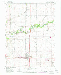
1961 Map of Kentland
USGS Topo · Published 1963About this map
The Pennsylvania Railroad and New York Central Railroad intersect at Kentland, anchoring the region's mid-century transportation and industrial activity. This survey captures a landscape defined by organized agricultural plots and an extensive network of drainage infrastructure like Garrard Ditch, supporting the productive plains of Washington and Jefferson townships. The Iroquois River meanders across the center, providing a natural break in the gridded road system where the County Fairgrounds and County Home are established.
Find a feature on this map
44 named features on this map. Tap any name to fly to it.
Don’t see what you’re looking for? This feature index may not catch every label — zoom into the map to look around manually.
Map Details
Editions of this 1961 Kentland Map
2 editions found
Other maps of this area

1935 · Watseka
USGS Topo · 1:48,000

1938 · Milford
USGS Topo · 1:48,000

1939 · Watseka
USGS Topo · 1:62,500

1944 · Milford
USGS Topo · 1:62,500

1953 · Danville
USGS Topo · 1:250,000

1955 · Danville
USGS Topo · 1:250,000

1956 · Danville
USGS Topo · 1:250,000

1961 · Mount Ayr
USGS Topo · 1:24,000

1961 · Morocco
USGS Topo · 1:24,000

1962 · Wadena
USGS Topo · 1:24,000