
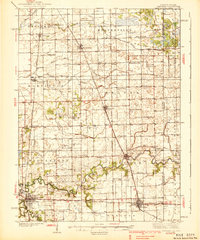
1939 Map of Watseka
USGS Topo · Published 1939About this map
Watseka and the surrounding Iroquois County landscape appear here as a hub of mid-century prairie agriculture and rail transit. This 1930s survey reveals a high density of rural schoolhouses such as College Corner Sch, Hesperian Sch, and Weygandt Sch, documenting the educational infrastructure before school consolidation reshaped the Midwest. The winding Iroquois River and Sugar Creek provide the primary natural drainage, though the landscape is heavily modified by an extensive network of man-made channels like Martinton Ditch No 1 and Whaley Ditch, illustrating early 20th-century efforts to reclaim wetland for farming.
Find a feature on this map
88 named features on this map. Tap any name to fly to it.
Don’t see what you’re looking for? This feature index may not catch every label — zoom into the map to look around manually.
Map Details
Editions of this 1939 Watseka Map
2 editions found
Other maps of this area

1922 · Momence
USGS Topo · 1:62,500

1922 · Kankakee
USGS Topo · 1:62,500

1924 · Momence
USGS Topo · 1:62,500

1924 · Kankakee
USGS Topo · 1:62,500

1935 · Watseka
USGS Topo · 1:48,000

1938 · Milford
USGS Topo · 1:48,000

1939 · Cissna Park
USGS Topo · 1:62,500

1944 · Milford
USGS Topo · 1:62,500

1944 · Gilman
USGS Topo · 1:62,500

1946 · Gilman
USGS Topo · 1:62,500