
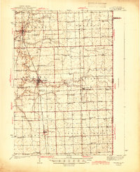
1944 Map of Milford
USGS Topo · Published 1944About this map
Milford serves as the central hub of this agricultural landscape in eastern Iroquois County, where the Chicago and Eastern Illinois railroad intersects with multiple local lines. The map reveals an exceptionally dense network of early 20th-century rural education, featuring dozens of localized schoolhouses such as White College Sch, New Gothic Sch, and Fidelity Sch spaced at regular intervals across the townships of Belmont, Stockland, and Lovejoy. This pattern reflects the era of the one-room schoolhouse before the mid-century trend of district consolidation.
Find a feature on this map
67 named features on this map. Tap any name to fly to it.
Don’t see what you’re looking for? This feature index may not catch every label — zoom into the map to look around manually.
Map Details
Editions of this 1944 Milford Map
2 editions found
Other maps of this area

1933 · Hoopeston
USGS Topo · 1:48,000

1935 · Watseka
USGS Topo · 1:48,000

1936 · Potomac
USGS Topo · 1:62,500

1938 · Milford
USGS Topo · 1:48,000

1938 · Hoopeston
USGS Topo · 1:62,500

1939 · Watseka
USGS Topo · 1:62,500

1939 · Cissna Park
USGS Topo · 1:62,500

1944 · Gilman
USGS Topo · 1:62,500

1946 · Gilman
USGS Topo · 1:62,500

1949 · Cissna Park
USGS Topo · 1:62,500