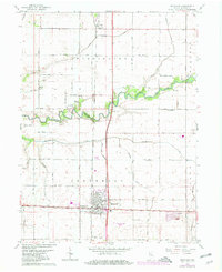
1961 Map of Kentland
USGS Topo · Published 1980About this map
The town of Kentland serves as the focal point of this Newton County survey, situated at the intersection of significant rail lines including the Toledo Peoria and Western and Conrail. The surrounding landscape is defined by the winding course of the Iroquois River and an extensive grid of section-line roads, such as 1500 South Road and Montgomery Road, which facilitate the region's agricultural character. Local heritage is preserved in several rural landmarks, including the Mt Zion Ch and its neighboring Mt Zion Cem to the northwest, and the Township Sch near the northern settlement of Ade. The presence of a large Quarry and the Kentland Municipal Airport south of town indicates a shift toward industrial and logistical infrastructure during the mid-20th century, while institutions like the County Fairgrounds and County Home highlight the community's civic foundations.
Find a feature on this map
38 named features on this map. Tap any name to fly to it.
Don’t see what you’re looking for? This feature index may not catch every label — zoom into the map to look around manually.
Map Details
Editions of this 1961 Kentland Map
2 editions found
Other maps of this area

1935 · Watseka
USGS Topo · 1:48,000

1938 · Milford
USGS Topo · 1:48,000

1939 · Watseka
USGS Topo · 1:62,500

1944 · Milford
USGS Topo · 1:62,500

1953 · Danville
USGS Topo · 1:250,000

1955 · Danville
USGS Topo · 1:250,000

1956 · Danville
USGS Topo · 1:250,000

1961 · Kentland
USGS Topo · 1:24,000

1961 · Mount Ayr
USGS Topo · 1:24,000

1961 · Morocco
USGS Topo · 1:24,000