1940s Maps of Noble County, Indiana
Explore 3 historic maps of Noble County from the 1940s. These maps offer a rare glimpse into what life looked like during the 1940s — showing old roads, neighborhoods, homes, and landmarks that have changed or disappeared over time.
Whether you're researching your family's past, planning a metal detecting trip, or studying how Noble County's landscape evolved across the 1940s, these high-resolution maps are a powerful tool for exploring the history of this region.
- Focus on a specific era: All maps on this page are from the 1940s, giving you a focused view of this time period.
- See what’s changed: Compare century-old streets, trails, and buildings to today's modern landscape using overlays and satellite layers.
- Research with precision: Use these maps for genealogy, historical research, land use analysis, or educational projects.
- View, download, or print: Maps are fully viewable online in high resolution, and can be downloaded or printed for your own records.
Start exploring Noble County's history through authentic maps from the 1940s. This is your window into the past.
Noble County, IN maps
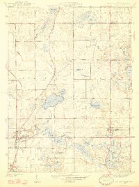
(3)- 1942 Map of Stroh
 1942 Stroh1942 Print · USGSNortheast Indiana’s lake country is captured here in the early 1940s, showing a landscape of small farming hamlets and lakeside landings. Researchers can trace family roots at Reed Cem or locate old community hubs like Salem Center and Helmer.2 unique versions available
 - 1947 Map of Wolcottville
 1947 Wolcottville1947 Print · USGSThe lake-strewn border of LaGrange and Noble counties is captured here just after the war, showing the vital rail junction at Wolcottville. Genealogists and local historians can trace family plots at Bethel Cem or locate the distinctive Kneipp Springs Sanitarium.2 unique versions available
 - 1947 Map of Oliver Lake
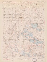 1947 Oliver Lake1947 Print · USGSLaGrange and Noble counties appear here just after the war, defined by a dense network of glacial lakes and small farming communities. Researchers can trace the legacy of local landmarks like the Rogers Orphanage, the Limberlost Camp, and family burial grounds including Osborn Cem.2 unique versions available
End of results
Showing maps 1-3 of 3
Top cities of Noble County
- Kendallville historical maps
- Ligonier historical maps
- Avilla historical maps
- Swan historical maps
- Albion historical maps
- Rome City historical maps
See more
Frequently asked questions
- What are the different types of historical maps available for Noble County?
- What is the oldest map of Noble County?
- Where can I purchase historical maps of Noble County for my home or office?
- Where can I download high-res historical maps of Noble County?
- Are there historical topographic maps available for Noble County?
- Is there historical aerial imagery available for Noble County?
- Where are historical maps of Noble County sourced from?