1970s Maps of Noble County, Indiana
Explore 5 historic maps of Noble County from the 1970s. These maps offer a rare glimpse into what life looked like during the 1970s — showing old roads, neighborhoods, homes, and landmarks that have changed or disappeared over time.
Whether you're researching your family's past, planning a metal detecting trip, or studying how Noble County's landscape evolved across the 1970s, these high-resolution maps are a powerful tool for exploring the history of this region.
- Focus on a specific era: All maps on this page are from the 1970s, giving you a focused view of this time period.
- See what’s changed: Compare century-old streets, trails, and buildings to today's modern landscape using overlays and satellite layers.
- Research with precision: Use these maps for genealogy, historical research, land use analysis, or educational projects.
- View, download, or print: Maps are fully viewable online in high resolution, and can be downloaded or printed for your own records.
Start exploring Noble County's history through authentic maps from the 1970s. This is your window into the past.
Noble County, IN maps
(5)- 1973 Map of Ligonier, 1974 Print
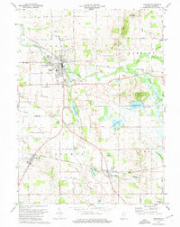 1973 Ligonier1974 Print · USGSNoble County in the 1970s is a landscape of glacial lakes and historic transit corridors, where the Elkhart River flows past the rail-hub of Ligonier. Genealogists can trace the Old Indian Treaty Boundary and locate family sites near Oak Park Cem or Sparta Cem.2 unique versions available
 - 1973 Map of Corunna, 1974 Print
 1973 Corunna1974 Print · USGSDeKalb and Noble Counties are shown in the early seventies as a series of well-defined rural townships and small rail-side settlements. Local historians can trace the foundations of the community through the Corunna Cemetery, Allen Chapel, and the Penn Central line.
 - 1973 Map of Garrett, 1974 Print
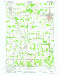 1973 Garrett1974 Print · USGSIn the early 1970s, the industrial rail center of Garrett and its neighboring agricultural townships were defined by the Penn Central line. Genealogists and local historians can trace family-named sites like Swan Cem and Embrey Cem, or locate landmarks such as Bethlehem Ch and the Old Railroad Grade near Altona.
 - 1973 Map of Albion, 1974 Print
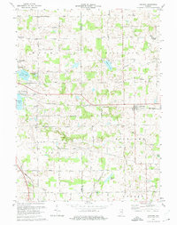
 1973 Albion1974 Print · USGSNoble County's glacial lake country and rail towns are captured here in the mid-seventies as the region's agricultural and industrial identity remained firmly rooted. Genealogists can locate family sites at Rose Hill Cem or Wright Cem, while rail historians can trace the paths of the Penn Central and Baltimore and Ohio.
 - 1973 Map of Kendallville, 1975 Print
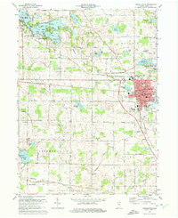 1973 Kendallville1975 Print · USGSKendallville and Rome City thrived as rail and lakeside hubs in the early 1970s. Researchers can trace family history through sites like Lakeview Cem, explore the grounds of the Gene Stratton Porter State Memorial, or locate the rural Sweet Ch.2 unique versions available
End of results
Showing maps 1-5 of 5
Top cities of Noble County
- Kendallville historical maps
- Ligonier historical maps
- Avilla historical maps
- Swan historical maps
- Albion historical maps
- Rome City historical maps
See more
Frequently asked questions
- What are the different types of historical maps available for Noble County?
- What is the oldest map of Noble County?
- Where can I purchase historical maps of Noble County for my home or office?
- Where can I download high-res historical maps of Noble County?
- Are there historical topographic maps available for Noble County?
- Is there historical aerial imagery available for Noble County?
- Where are historical maps of Noble County sourced from?