1940s Maps of Owen County, Indiana
Explore 3 historic maps of Owen County from the 1940s. These maps offer a rare glimpse into what life looked like during the 1940s — showing old roads, neighborhoods, homes, and landmarks that have changed or disappeared over time.
Whether you're researching your family's past, planning a metal detecting trip, or studying how Owen County's landscape evolved across the 1940s, these high-resolution maps are a powerful tool for exploring the history of this region.
- Focus on a specific era: All maps on this page are from the 1940s, giving you a focused view of this time period.
- See what’s changed: Compare century-old streets, trails, and buildings to today's modern landscape using overlays and satellite layers.
- Research with precision: Use these maps for genealogy, historical research, land use analysis, or educational projects.
- View, download, or print: Maps are fully viewable online in high resolution, and can be downloaded or printed for your own records.
Start exploring Owen County's history through authentic maps from the 1940s. This is your window into the past.
Owen County, IN maps
(3)- 1947 Map of Gosport, 1958 Print
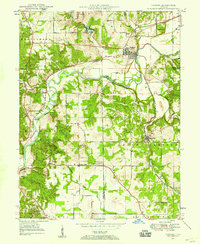 1947 Gosport1958 Print · USGSMid-century Owen and Monroe counties are seen here through their winding river valleys and small railroad towns. Researchers can trace the heritage of rural congregations and family lands near Stinesville, Shiloh Ch, and the Chambersville Cem.
 - 1948 Map of Coal City
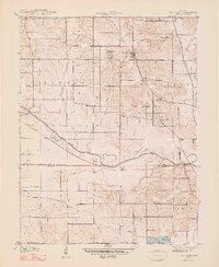 1948 Coal City1948 Print · USGSThe rural borderlands of Owen, Clay, and Greene Counties are shown here during the late 1940s, showcasing a landscape shaped by coal mining and transport. Researchers can trace the path of the Wabash and Erie Canal (Abandoned) and locate vanished landmarks like Stockton, Sink Cem, and the College Hill Sch.2 unique versions available
 - 1949 Map of Quincy
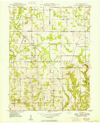 1949 Quincy1949 Print · USGSOwen County’s rural townships are captured in the late 1940s, centered on the railroad hub at Quincy. Genealogists can trace family landmarks like Little Mount Cem, Montgomery Chapel, and the vanished School No. 2 near the Morgan County line.2 unique versions available
End of results
Showing maps 1-3 of 3
Top cities of Owen County
Frequently asked questions
- What are the different types of historical maps available for Owen County?
- What is the oldest map of Owen County?
- Where can I purchase historical maps of Owen County for my home or office?
- Where can I download high-res historical maps of Owen County?
- Are there historical topographic maps available for Owen County?
- Is there historical aerial imagery available for Owen County?
- Where are historical maps of Owen County sourced from?