1940s Maps of Pike County, Indiana
Explore 4 historic maps of Pike County from the 1940s. These maps offer a rare glimpse into what life looked like during the 1940s — showing old roads, neighborhoods, homes, and landmarks that have changed or disappeared over time.
Whether you're researching your family's past, planning a metal detecting trip, or studying how Pike County's landscape evolved across the 1940s, these high-resolution maps are a powerful tool for exploring the history of this region.
- Focus on a specific era: All maps on this page are from the 1940s, giving you a focused view of this time period.
- See what’s changed: Compare century-old streets, trails, and buildings to today's modern landscape using overlays and satellite layers.
- Research with precision: Use these maps for genealogy, historical research, land use analysis, or educational projects.
- View, download, or print: Maps are fully viewable online in high resolution, and can be downloaded or printed for your own records.
Start exploring Pike County's history through authentic maps from the 1940s. This is your window into the past.
Pike County, IN maps
(4)- 1944 Map of Glendale
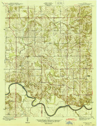 1944 Glendale1944 Print · USGSDaviess County during the mid-1940s is defined by the winding East Fork White River and the rural crossroads of the Indiana countryside. Researchers can trace ancestral roots through local landmarks like Glencoe Cem, Pennyville, and a Coal Mine near High Rock.2 unique versions available
 - 1944 Map of Monroe City
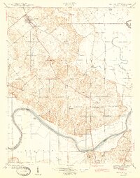 1944 Monroe City1944 Print · USGSMonroe City and the surrounding Knox County bottomlands are captured here in the 1940s, just as the rural landscape was maturing. Researchers can trace family origins through numerous landmarks like Freeland Cemetery, Hamline Chapel, and Slickum School.2 unique versions available
 - 1944 Map of Iona
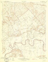 1944 Iona1944 Print · USGSKnox and Gibson counties meet along the high-banked curves of the White River in the early 1940s. Researchers can trace rural lineages through numerous local sites including Slow Cem, West Salem Cem, and the settlement at Iona.2 unique versions available
 - 1945 Map of Sandy Hook
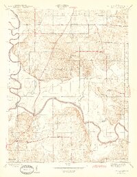 1945 Sandy Hook1945 Print · USGSDaviess County was a landscape of small schoolhouses and river junctions during the 1940s. Genealogists and local historians can trace family locations near Union Cemetery or locate old community centers like Sandy Hook and Needmore Sch.2 unique versions available
End of results
Showing maps 1-4 of 4
Top cities of Pike County
Frequently asked questions
- What are the different types of historical maps available for Pike County?
- What is the oldest map of Pike County?
- Where can I purchase historical maps of Pike County for my home or office?
- Where can I download high-res historical maps of Pike County?
- Are there historical topographic maps available for Pike County?
- Is there historical aerial imagery available for Pike County?
- Where are historical maps of Pike County sourced from?